FLOW BOULEVARD
A 50 MILE NETWORK OF LA BASIN FLOW BOULEVARDS
January, 2022
CONTENT OUTLINE
1. THE 50 MILE PLAN
2. 4 BILLION POUNDS OF CO2 REDUCTION
3. HOW DOES CONTINUOUS FLOW TRAFFIC WORK?
4. BIKE LANES, WHERE TO PUT THEM
5. SOLUTIONS BEST MADE WITH FLOW BOULEVARDS
6. EQUITY; FAIRNESS TO EVERYONE
THE 50 MILE PLAN
The Flow Boulevard system is a breakthrough for transportation and land use improvement in the Los Angeles Basin. When do you ever see the capability of the doubling of vehicular capacity on 50 miles of LA Boulevards that supports a variety of transit and vehicular improvements leading to community land use density growth improvements for the cost of less than one mile of subway? With all the money that is cued up to serve infrastructure improvement, public transit, jobs, and fighting Climate Change, there has to be enough for 50 miles or more for Flow Boulevards. Money sources are the Infrastructure and Jobs Act, with more than $200 Billion (reference; https://www.whitehouse.gov/briefing-room/statements-releases/2021/11/06/fact-sheet-the-bipartisan-infrastructure-deal/ ) which includes safety programs and EV buses, and then there is Gov. Newsom’s fight on Climate Change where transportation is the biggest target for reducing GHG emissions, and these improvements encompass the Los Angeles Planning Departments’ new call to provide 486,000 new housing units in Los Angeles by the year 2029.
The fact that the 50 mile network of LA Basin Flow Boulevards would connect a number of transportation systems and modes of travel should convince both commuter and local travelers that it would be a necessary improvement in efficiency that promotes an opportunity to provide greater productivity to citizens in the many communities in the LA Basin in terms of mobility, socio-economic opportunity and livability, and that it should structure where new housing mainly is to be built.
A Flow Boulevard (FB) eliminates congestion, greatly reduces CO2 emissions, and provides the ability to address the many problems that the various communities face through the bottom up process of corridor/community planning. The network makes a wide range of opportunities, from the communities that are isolated by insufficient accessibility, to those communities overrun by uncontrolled cut through traffic. The FB Network is a practical and low cost expenditure for fighting Climate Change and of making essential opportunities to each community to make Los Angeles the innovative 21st century city you would expect it to be. A new urban boulevard system, a first of its kind in the world, structures the new benefits to communities with continuous flowing traffic on urban interrupted streets at grade in existing rights of way without the widening of streets. The USPTO new patented roadway system, was granted on March 23, 2021.
The Flow Boulevard (FB) system is a new category within the hierarchy of urban roads between freeways and regular boulevards. With the greater capacity for moving people and goods, the FB solves the congestion problems in the LA Basin uniting freeway access to FBs and connects bus transit on FBs to the downtown rail hub for commuters and on to the regular network of boulevards with the high capacity ability of continuous flowing traffic on Flow Boulevards.
This transportation proposal really works well with the City Planning Department’s new Housing Element by giving a structure to attach the additional housing units to and the improved public bus transit in corridors that would be made.
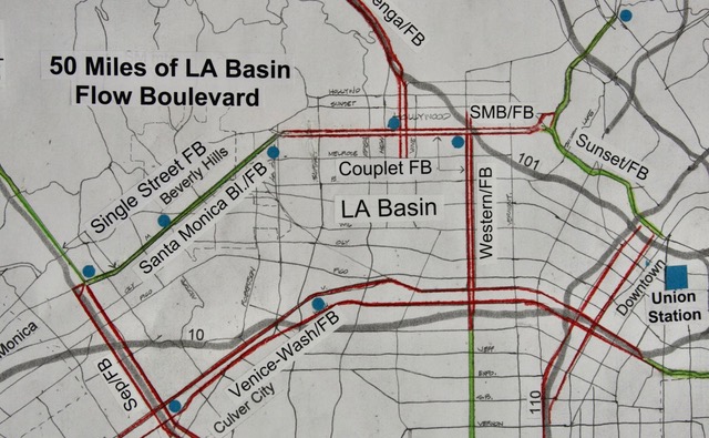
The 50 mile plan above delineates the two types of roadway corridor and traffic signalization that brings about continuous flowing traffic on the proposed Flow Boulevard LA Basin Network. The corridor type that is the primary innovation is the continuous flowing traffic on an existing single street right of way (R.O.W.). The addition to its connections to Couplet corridors and the connections through interchanges to other Flow Boulevard corridors, rounds out the ability to make Networks of Flow Boulevards. The segments of Single Street Flow Boulevards at grade, with synchronous signalization in two way traffic are shown in green on the plan. The second type of corridor with continuous flow traffic in the planed network is the Couplet Flow Boulevard with two one-way streets separated by a block or more, which have progressive signalization and are shown as red lines in the plan above. As seen in the plan, Couplet FBs comprise the majority of corridor mileage. However the key to the network has been in the innovation of the Single Street FB and its ability to provide continuous flowing traffic where a second parallel street to make a couplet with is not present in a corridor to be made. As well, it is the innovation of connecting Single Street FB segments to Couplet FB segments along with connections of these corridor segments through FB interchanges, that also provide continuous flow of traffic in the connections of both the Single Street FB and Couplet FB together, that allows a network to be made.
The Single Street Flow Boulevard provides the continuous flowing traffic by simplifying the structure of cross traffic by reducing direct cross traffic intersections to just one mile intervals so that long packs of vehicular traffic can be made to increase the amount of traffic to flow at urban low safe speeds in that corridor. In this basic explanation assume a 30 mph traffic in opposing directions that makes a traffic signal recycle of every two minutes (120 seconds), at what is called an on-module intersection each mile where direct traffic crossing of the Flow Boulevard is made through a 40 second gap between two FB 80 second long packs of vehicles. Division of the 120 second signal cycle is made to allow the FB to have a longer green light period so each lane of the FB carries more vehicles than does the traffic of the crossing street lanes would have in order to expand the FB capacity. That gives each lane of the FB the more than twice the capacity on a lane per lane basis than the direct crossing street lanes at the on-module intersections. Between the flowing packs of traffic on the FB there are the 40 second gaps which allows the signalized stop and go cross traffic to go through the gaps of the FB flowing packs of vehicles as well as the turning movements of both the FB and the crossing street to exchange with each other that occurs during each on-module intersection period.
Between on-module intersections the gaps in the FB flowing packs allow traffic movements between the abutting local streets and the FB to access with each other land uses along the FB. A median in the center of the FB structures traffic movements from one side of the FB abutting local streets to cross the FB to the other side of the FB in a number of crossing movements that use turning pockets in the median. That is the basic structure of the single street FB. Exhibits below will diagram such traffic movements as well as the movement of the continuous flowing packs of vehicles on the Flow Boulevard.
Before that occurs in the How Does Continuous Flow Traffic Work section, some words on how FB corridors begin and then become a network is in order. The beginning assembly of FB corridor segments deals with the starting and ending of a FB segment within a street area of stop and go traffic streets or to where a freeway entry and exiting of connecting traffic occurs, or both if the traffic demands it to be so. The traffic at these lower and higher capacity networks need to be compatible with the existing travel demand so that disruptive congestion does not occur. The Flow Boulevard has flexibility within its structure to provide traffic management, and in combination with how the FB is connected to higher or lower capacity networks and their travel demand, can make compatibility occur. At this point simply understand that FBs need managed growth of continuous flowing traffic to afford the ability to double the roadway capacity to become this new urban roadway that fits within the hierarchy of roads between a freeway and a regular stop and go boulevard network.
In using existing streets to be transformed into a FB, that existing amount of travel in the corridor will fit within the FB structure leaving room and time for growth in this safe, controlled traffic corridor. The amount of traffic in corridors are analyzed in regards to the travel demand. Travel demand is a method of establishing how much demand for movement through an area there is to be designed for and managed within a roadway system. The travel demand for this Flow Boulevard network has used the travel demand that the Los Angeles Regional Transportation Study projected, and used the Manual Assignment Technique method to arrive at the adequacy of various critical segments of the 50 Mile LA Basin Flow Boulevard network.
The FB system grows over time, segment by segment making sure capacities in either direction through the last on-module intersection (an end on a FB segment) does not exceed the capacity to exit or receive the traffic in the connections between the existing stop and go traffic network, or with freeway ramp access, to which connections are made with the FB. The point is the FB system can be and must be managed to be compatible at the end of each FB segment as the segments are added to over time to build the network. Corridors of Flow Boulevards can be developed with Single Street FBs connected to Couplet FBs and be complete in operation. And these corridors can be connected as well through the FB Interchanges where FBs cross one another.
This is how the Flow Boulevard Network grows in length and in capacity by matching the roadways to which it is connected to. As travel demand grows in the corridor or the segments of the corridor, the capacity within the Flow Boulevard system can increase along its corridor by many managed factors; for example the number of lanes a new segment may have, amount of green signal time that is made in the traffic signal cycle that is made, and can even have its speed changed through a segment that accelerate traffic in one direction and decelerates traffic speed in the other direction, thereby making a change in speed and capacity in a corridor. Over time and with managing the connection to other segments, the FB segments are developing the ability that doubles capacity within the Flow Boulevard system to eliminate congestion overall, reduce great amounts of CO2 emissions and allows greater land use density to be developed and be served. Air quality is getting better with each connection made.
A major completion of the 50 mile network is when the “thirty eight mile basin loop” comprised of the Santa Monica/Sunset FB on the north side is connected to the Sepulveda FB on the west side, and it is connected to the Venice/Washington FB on the south side, and then connected to a combination on the east side with the Western FB and the one-way streets that link to the Union Station Hub of Modes and is also connected to the Santa Monica/Sunset FB to close the loop on the north side to act like a circle. At that point the loop can operate 24/7 with traffic going around and around in both directions without the connecting travel capacities being at issue. At this point the LA Basin Loop is complete and well advanced to allow the doubled capacity for its lanes all the way around. Extensions of FBs can extend out from this loop to other areas of the city. During the building of increased capacity the building of additional land use density can occur with balancing the capacity with the additional travel demand that is made. Land use and the corridor capacity can grow together.
The east side of the LA Basin loop will probably be complex in its managed connections in that the closed loop is made by both the Western FB segment, the connections to the Union Station Hub of modes and also extensions of the Santa Monica/Sunset FB into East LA as well as the extension of the Venice/Washington FB that connects to on and off ramps of the part of the 10 Freeway that serves the Downtown area. One-way street connections in both directions will serve in supplying most of the connections that goes by the Union Station rail hub. As can be seen, the FB Network evolves over time as new connections are made and as the growth in travel demand occurs. Flexibility within the FB structure and timing of signalization allows balance to be achieved among the segments through the managed response to changes in travel demand and capacity on the segments of the network as FB segments are added.
4 BILLION POUNDS OF CO2e REDUCED BY 50 MILES OF FLOW BOULEVARD
At the regional scale the objective is to reduce further sprawl and its accompanying growth in VMT (vehicular miles traveled) by creating urban environment where shorter trips result. This refers specifically to a transitional period of time going from 90% of trips being made with fossil fuel powered vehicles to an EV transportation city which has higher density. This calls for making existing developed areas of Los Angeles to have greater density thereby with the proximity of the mix of urban land uses that make cities work efficiently, shorter trips are being made. The LA Basin, with its major job centers, can become even more efficient with greater density and in the process revive the LA economy and bring about community problem solving and opportunity for its citizens. In order to do that, improved roadways and mobility needs to be structured to support the greater density and can also fight Climate Change while doing so. Making the LA Basin more efficient also relates to the regional scale also becoming more efficient.
There are two major ways the Flow Boulevard reduces CO2 emissions at the scale of the LA Basin. One is with making greater efficiency of the 90% of fossil fuel (FF) vehicles to have flowing traffic instead of stop and go traffic, and by eliminating congestion in traffic directly. Secondly, uncongested traffic will promote the development of fast and frequent EV bus service that would attract ridership and a reason to not drive FF vehicles. The recent past showed that without fast and frequent bus service due to congested streets, former bus riders were buying cars to get to jobs further away and other major destinations. In a simple way, EV bus service by being fast and linking to regional systems such as rail and freeways, it also quickly connects to a multiple of other communities in the 50 mile FB Network. Instead of bus-riders being locked in congested traffic with travel speeds from 4 mph to 12 mph at peak hours, a bus rider can expect a consistent 25 to 28 mph on a 30 mph Flow Boulevard. Faster times on a 35 mph FB could be made as well. Besides a faster ride, the FB system will connect much more directly to rail systems of travel and would greatly expand job opportunity discovery and connection. This refers to basin residents seeking access to suburbia, as well as suburban commuters seeking greater access to areas within the LA Basin.
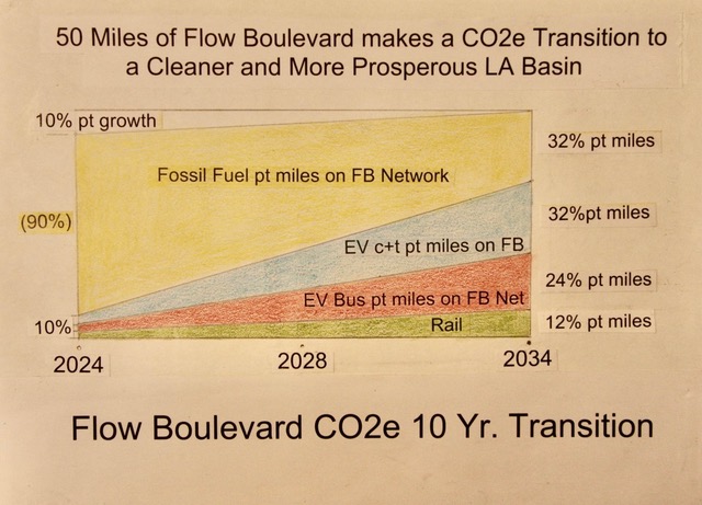
Improvements in mobility trends can also quickly fight Climate Change. Below is a chart showing where person trips (pt) in fossil fuel cars become fewer as the transition of person trips to EV vehicles and EV buses with faster and more frequent service is made. The savings of emitting fewer tons of CO2 emissions is significant within the 50 mile Flow Boulevard Network, as calculated below.
By having the 50 miles of doubled increased vehicular capacity, that allows for not only the elimination of congested boulevards and CO2 reduction, it also allows for greater land use density which means economic growth and on average, shorter trip length between destination points making fewer VMT as a result. This makes a more efficient city and one with greater opportunities for citizens in their improving communities. Affordable housing fits into this paradigm of higher density, close by learning, working, socializing and low cost transportation in EV buses.
The chart above depicts a potential 10 year period of change with a transitioning of the 90% of person trips now made in the dominant fossil fuel (FF) vehicles to the future 2034 person trips made by fewer FF cars and more trips made in the EV vehicles and buses. The average per year reduction over the ten years of fossil fuel cars can be said to be a 6% reduction per year for ten years equaling a total of a 60% reduction in FF emissions on the FB. Is that amount big in terms of reducing CO2 emissions?
To figure what amount of savings in gasoline not being burnt and filling the air with CO2 emissions, we turn to the EPA Moves Program to calculate the savings. The savings is from having a continuous flowing of traffic at 30 mph which will have less burning of fossil fuel than at the 15 mph average of the less efficient speed that is made on stop and go traffic boulevards. The difference in the amount after converting the energy in btu consumption rates, as found in the Moves Program Table into gallons of gasoline, is a saving of 0.018492 gallons/mile/vehicle. The capacity of the 50 miles of FB is 4,875,000 person trip/miles/day. While the capacity is not made in the first years of operation, figure that the average for the ten years is the midpoint in 2028, which would include the savings of the adjacent now decongested miles of traffic made on adjacent regular boulevard streets by also moving over to the Flow Boulevards that saves gasoline. So multiplying the capacity time of 60% will give a pretty close approximation of the number of gallons being saved from becoming CO2 emissions per day. The average 60% amount of capacity is 2,925,000 miles per day times the 0.018492 gallons/mile/vehicle which equals 54,089 gallons saved per day times 360 days/year equals 19,472,040 gallons saved from becoming CO2/year. Multiply that times 20 pounds per gallon equals 389,440,800 pounds of CO2/year for that mid 2028 year. Now multiply that times 10 years to get a total of the 4 billion pounds saved by the tenth year in 2034. That should make a lot of credits to help build communities besides the now increased property tax revenues from the increased density of land uses. What credits?
The savings in unburnt gasoline is great for fighting Climate Change quickly. But there is also the opportunity to help communities to solve their problems, as the Air Resource Board (CARB) enters the design and approval process which is were credits may be earned by lowering emissions of CO2.
The reason to address this issue of environmental law is to clarify what requirements are in the corridor plan studies so that progress is not held back in the implementation stage of construction. A second reason is that it is possible to gain credits that can offset regulations that would allow less expensive needed low cost housing to be built and other opportunities. Even though the cost of the FB Network is low, extra money for community development would be welcome. The cost for 50 miles of FB, would be less than the cost of one mile of subway which is 800 million per mile. Divided by 50 that averages is less than $16 million/mile on average. However, the cost of FB improvement may be as low as $11 million/mile (or even less if grade separated intersections are not needed in a corridor segment). There are four or five such grade separated intersections needed within the 50 miles of FB as seen in the 50 mile plan to date.
A key issue with the AQMD is that the local air district can have the authority to construct. Below are quotes from their website at https://www.arb.ca.gov/permits/airdisac.htm.
From Section I; Quote, “Air districts issue permits and monitor new and modified sources of air pollutants to ensure compliance with national, state, and local emission standards and to ensure that emissions from such sources will not interfere with the attainment and maintenance of ambient air quality standards adopted by the California Air Resources Board (CARB) and the U.S. Environmental Protection Agency.”
From Section V, paragraph 3: Quote, “There are two major requirements in each district New Source Review Rule: Best Available Control Technology (BACT) and offsets. Many air districts require BACT and offsets for any increase in emissions from a new or modified stationary source, as opposed to a mobile source. Others have established emission thresholds which trigger BACT and offset requirements when emission increases from new or modified sources exceed these thresholds.”
From Section V, paragraph 7; Quote, “If developer-applicants reduce emissions below actual emission levels allowed by the local air district, they may in some cases "bank" the reduction in actual emissions for use as offsets for future projects. Emissions banked in this manner can be used as offsets by the developer-applicant or sold, in whole or part, to other sources seeking offsets.”
An answer to the AQMD requirements is, the FB does not emit new sources of pollution. Quite the contrary they emit less. Because the FB system does not increase CO2e but actually reduces them, it would be “the” BACT system available. And the corridor study would also be looking for credits to help off-set the various other improvements that may increase improvement costs to the community. The credits would give a break to be less expensive by not being incombered, for example, with costly environmental costs as in the case of affordable housing. Excessive zero emission housing costs could be off-set by the credits gained in the less polluting FB. And because affordable housing could forgo the parking requirements being built for each unit in the FB public transit corridor construction costs can be saved. These factors can make new housing much more affordable when attached to at-grade commercial or live-work units on the first floor of a FB corridor building. So including environmental law compliance to recognize that the FB is a stationary source but its design makes it a more efficient source, is a way to get credits as part of FB corridor study and planning. Also, without the FB system which increases roadway capacity, it is questionable if there would be a successful increase in bus transit ridership that contributes so much to the reduction of emissions. Therefore the calculation of 4 Billion pounds of CO2 of GHG emissions due to gasoline not burnt is of importance in obtaining credits and clean air while fighting Climate Change. It should be noted that more gasoline would be saved in that there would generally be less congestion in the LA Basin. And regionally, trips are getting shorter and more commuters are hooking up with rail to connect with convenient FB distribution and collection in the Basin. That all adds up to much more than the 4 Billion pounds claimed above. The FB Network will grow as well making additional corridors that save more gasoline from being burnt.
HOW DOES CONTINUOUS FLOWING TRAFFIC WORK?
Below are diagrams to help communicate and visualize the operation of what the single street Flow Boulevard looks like that provides continuous flowing traffic. Cross traffic is represented with crossing boulevard traffic intersections as on-module intersections. The one mile module makes sense in that many areas of Los Angeles are laid out on a grid of one mile boulevards especially in the first ring of suburban areas like the San Fernando Valley and in South LA. Companion to the single street Flow Boulevard is the Flow Boulevard Couplet which is explained elsewhere in this text and has progressive signalization which does not need a module for crossing street traffic and it works well in older sections of the city where closely spaced streets in a grid are found. The only real change is in the timing of the traffic signal cycles which makes for a very low construction cost generally for FB Couplet corridors.
The two miles indicated in the diagram below for single street FBs is to show that the structure for each mile is the same so packs of traffic flows in both direction flows continuously. The traffic signal timing is called synchronous timing in that all the intersections are synchronized to repeat the same traffic signal cycle at the same time, in each one mile intersection over and over again, which allows the packs of traffic in both directions to flow continuously in the Single Street Flow Boulevard corridor. This is because the packs of vehicles in each direction are traveling at the same speed and covering the same amount of distance between each on-module intersection.
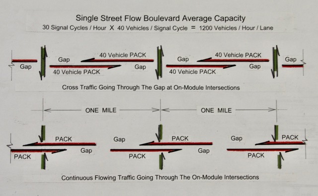
It can be seen in the diagram above, on the top image, that the vehicular packs do not align themselves for direct one movement crossings except for the direct crossing at the on-module intersections. In the lower image in the diagram above however, abutting local streets between the one mile on-module intersections show gaps in the continuous flowing traffic which allows abutting local street in the diagram further below, the use of the turning pockets in the median for a vehicle to go through the gap between the near flowing pack of vehicles to get to the median and then wait until there is the gap between the far flowing packs in order to turn and cross those lanes to get to the other side or flow in the FB lanes. So there are ample turning movements to give circulation between the FB and the adjacent land use between on-module intersections.
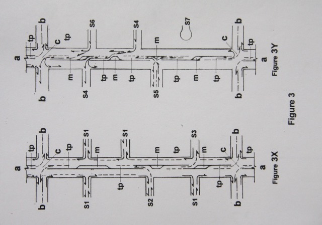
Below is a diagram showing various possible traffic turning movements that allow accessibility between the abutting side streets between on-module intersections of the Flow Boulevard which occur at the one mile intervals. You will notice that each abutting side street between the on-module intersections does not allow direct crossing of the FB in one motion. It takes more than one movement of the vehicle to get across both of the opposing direction of traffic to get to an abutting side street on the other side of the median or into the traffic lanes beyond the median.
Right turns from a side street into the FB can be made in one movement and right turns off the FB into a side street are made in one movement. And of course between the on-module intersections occurring every one mile a vehicle can stop at curb side lanes to park. The various turning movements shown below are basically made during the opportunities made during the gap periods between the on-module intersections. This is not unlike existing two way streets within existing boulevards that have medians. However, it is likely due to the traffic volumes involved that most of the vehicular movements from abutting local streets to the median would have traffic signals to make sure safe movements occur in the gaps of traffic between the flowing packs of vehicles. Pedestrians and bike riders using pedestrian crossings can traverse the FB at signalized crossings to the median and then from the median to the other side of the FB.
The curb lane in the Single Street FB is expected to evolve in use as the FB corridors grow in travel demand and bus ridership. More buses, right! Not only more buses many kinds of shared vehicles with short term duration will need a place at the curb to do their part in moving people and to support commercial services in the corridor. This evolution of curb use will demand that longer term parking be placed near by. The local abutting streets to the FB can be arranged to have more parking if the community works that out in their community plan. This would tie into planning of the higher density corridor and with the desire to use local streets to provide more open space for pedestrian use, bike lanes, as well as having more pedestrian oriented housing that does not depend so much on vehicle ownership. Let’s get architects working on the various neighborhoods, housing and buildings in the city, working on these ideas.
BIKE LANES, WHERE TO PUT THEM
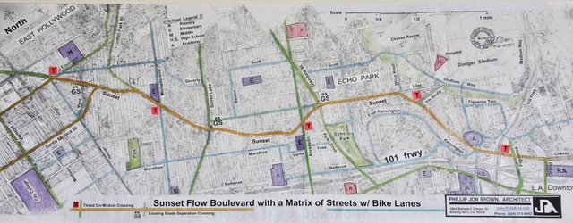
This brings up the issue of bike lanes generally. The first point is that in the LA Basin there are various boulevard street widths in this proposal of 50 miles of FB that would not allow bike lanes without excluding vehicular flow lanes on a FB. Sunset Boulevard is one of those boulevards. In other proposed FB segments there are ample street widths so that bike lanes can be included. In fact there are several segments of the proposed FB 50 miles that currently have bike lanes and could remain as such in the FB proposal. However when it comes to a condition where a bike lane removes the ability to have a needed vehicular flow lane on a FB, the bike lane should find other nearby streets for that function. There are a multitude of streets that can take bike lanes which can provide safe routes to bike on. Actually residential streets provide the safety and connectivity at the community scale that is more appropriate for general bike riding use.
The plan of the proposed Sunset Flow Boulevard, shown below (in gold), has Sunset connecting to Downtown Los Angeles which would then connect to the Union Station Commuter Rail Hub as well as an extension (not shown), of the Sunset traffic into East LA. So the Sunset FB has very important areas to connect to. Losing the capacity to serve those connections would be an unacceptable impact to mobility in that area and to the 50 mile network function as well. Also, the Sunset FB on the westerly flow of traffic would connect to the Santa Monica FB and traverse all the way to West LA on Santa Monica then connect to the Sepulveda FB that would continue to the San Fernando Valley to the north and from the Santa Monica FB connection to go southerly to Culver City and likely beyond that.
The disruption by a few miles of bike lanes down grading the Sunset ability to carry much needed current and future EV vehicles and EV bus trips is not a realistic trade off. Especially in the plan below, where bike lanes on residential local collectors (shown in blue and other boulevards shown in green) are available to make bike lanes that connect to schools, parks and institutions for the convenience of residents as well as for those who would pass through the Echo Park District.
Also, there are many regular boulevards that do not align well in order to be part of a FB Network that can probably have a combination of regular boulevards, and the next lower street order in the hierarchy which would be local collectors, to make a complete network of bikeways across the Basin to serve those who would use them without costing much. The bike lanes in boulevards often can degrade the capacity and safety to adequately serve the travel demand that exists and is often not used when built, as has been demonstrated.
THREE SOLUTIONS MADE WITH FLOW BOULEVARDS
It is time to have collaborative efforts to be made between the City of Los Angeles, Metro other Cities, where urban design incorporates the better mobility, land use and community improvement together.
THE FIRST SOLUTION IS TO MAKE A NEW TOWN.
The first solution to mention is to develop, in effect, a New Town on the Venice/ Washington FB west of La Brea to beyond the 405. The New Town would build upon the new increased vehicular capacity by having a substantial additional amount of new housing with the facilities and commercial to support services for the New Town population. It would be designed to enhance Culver City and the corridor study would start the creativity going to be added to by Culver City planning as well as the necessary additional groups that would participate in planning and building the New Town. It of course builds upon the improved capacity and its connections in the FB Network that reduces VMT, CO2e, and provides a rich urban density that provides for opportunity, choice as well as economic growth.
THE SECOND SOLUTION IS TO SOLVE THE WESTSIDE 405 TRAFFIC PROBLEM.
Besides solving the general LA Basin congestion problem and establishing a better structure to proceed within the Basin, there are individual solutions of special note.
The West LA Sepulveda FB solution that would add the necessary extra capacity to the 405 corridor so there is not a break down of the commuter traffic to and from the Westside is one of those special problems to be solved. The 405 itself has episodes of 20 mph traffic. The heavy rail Purple Line addition to the Brentwood area means the inevitable additional related high rise office towers which attract even more trips, cars and other vehicles to the area which would put further demand on the regular boulevards of the Westside. And the cut through traffic in Brentwood may result as an even bigger problem of cut through traffic than there is today.
A serious study and plan development is needed to analyze and solve the problems that very much deal with commuter traffic on boulevards west of the 405. To date Metro is taking care of its job of regional travel demand. However the community scale of traffic in Brentwood is not being taken care of. The basic concept of the Flow Boulevard design, that has been made to date, deals with increasing capacity that allows trips to go around outside of Brentwood connecting the Valley commuters with the destination of the Santa Monica business districts. The objective is to reroute the Valley traffic so there is not the 28,000 trips per day of commuter traffic that cuts through the residential area between the Sunset and the San Vicente/Wilshire boulevards. The residents of the Westside should be demanding a complete resolution of travel demand that would include the community scale as well as the regional scale. Whereas Metro plans to solve its regional scaled traffic problems, it is the LA City that should be working to solve the relevant community traffic problems that are part of that traffic problem in the Westside. Metro has a Call For Project program which is geared to the community scale, where Metro with its money and abilities can be brought to work with the city of Los Angeles to solve traffic problems. So far Los Angeles has not called for a project that will solve its related 405 traffic problems in the Westside. It is time that happens before the Purple Line is finished and Metro says we’re done.
The 50 Mile LA Basin plan has a preliminary study that makes a solution to the community scaled traffic problem on its boulevard system and it helps solve the 405 Freeway traffic problem as well. The FB increased capacity proposal would consider a Sepulveda Couplet FB that would straddle the 405 with Sepulveda on the east and which includes the west side of the FB couplet connecting a southbound two lane off ramp from the 405 north of Santa Monica Boulevard which eventually connects via Beloit to the south bound portion of the Sepulveda FB Couplet on Sawtelle Boulevard south of Olympic Boulevard. This requires half a portion of Beloit and unused 405 land area to make a three lane roadway connecting the off ramp to the Sawtelle connection. Better to take roadway area to expand roadway capacity than to destroy Brentwood with cut through traffic. Additional Metro involvement would improve use of the existing two lane ramp connections in the 405/I-10 interchange to have additional freeway transition lanes to better merge traffic at the beginning and end of the ramp connections to serve the turns coming and going from the 405 to the I-10. The last bit of rerouting would be to use more exiting and on ramps on the west to connect the I-10 and the Santa Monica business district. The LADOT has to work with Metro, and a consulting team in a creative manner to solve the two scales of travel demand so as to work well with communities. It is time LADOT stands up for the people to participate in that problem solving.
THE THIRD SOLUTION IS TO SOLVE THE BEVERLY HILLS TRAFFIC PROBLEMS
The problem to be solved for in the long term is to the portion of the Santa Monica Boulevard (SMB) adjacent to the Beverly Hills (B.H.) business district directly south of the Boulevard. Presently there is a lack of vehicular capacity to deal with the through commuter traffic. Secondly the commuter through traffic is in conflict with the direct use of the residents to directly go to and from the residential area to the north to the business district to the south of SMB. Adding the continuous flowing traffic in a Santa Monica FB for the through traffic makes that work. There is also need to make a separate route to serve the B.H. business district separately so congestion does not develop with turning movements into the business district from a SMB FB. A western portal to Santa Monica South begins just east of Century City which connects directly to the B.H. busines district on Santa Monica South. A similar portal in the east that separates traffic destined to the B.H. business district on existing streets should be made to connect with Santa Monica South in combination with Burton Way. That makes an exclusive roadway that reduces congestion on a Santa Monica FB, gives access to the business district needs and it opens the area east of the B.H. business district south of a SMB FB for additional area for development of business and high density residential. The separation of the destined traffic from the through traffic works well for the Beverly Hills residents which would have direct uncongested connection to and from their business district.
FLOW BOULEVARDS ARE SAFE AND MAKE BETTER COMMUNITIES
What is basic to understand, is that the FB is essentially a very safe roadway to drive. The vehicles flowing on the FB are all traveling at the same speed with ample spaces between vehicles, approximately a bit more than 70 foot long gaps between vehicles when the boulevard is at full capacity and much more space when the FB begins operation in order to allow very safe movements from one lane to another. Courtesy is expected for the adaptation to this new roadway. The saving of time, eliminating congestion and so many other reasons why it is important to adapt to would be worth it.
Regarding safety, admittedly there are a lot of new relationships to get used to with FBs. But they are not that different from boulevards with painted medians for traffic movements. Still they would be different enough to make it be safe to learn these relationships in a spacious condition where there were ample distances between vehicles. The probable first stages that the public would get to know would be in a FB corridor that would be about half capacity with a great deal of space between vehicles. It would be good to have that beginning corridor to have both the single street FB and the Couplet Street FB in the corridor to learn both types of FB roadways. The continuous flow of traffic in and between these new urban roadways will amaze and bring support for the network to be developed in total. The State may require a portion of the driver’s test to drive on a FB. DMV can research these issues and ask for best practices to assure safe operations are being advanced.
In a similar adaptive procedure, the signal cycle allocation of time division between what time is given to the FB continuous flow traffic on the FB, as first explained as 80 seconds, and the amount of time given to cross streets (40 second) could be closer to what is currently a familiar divide on a particular street as, 65% boulevard traffic in shorter packs, and 55% of the signal cycle at a boulevard cross street. This would allow the necessary improved roadway connections to be completed and not have congested occurrences in the interim. There is a lot of flexibility to be recognized and the management of traffic to be made during the construction of the network.
Although the relationships with the LA ATSAC (Automatic Traffic Surveillance And Control) system has not yet been studied, the features that allow surveillance and control would enhance what is now a simplified basic safe FB system to begin with. The surveillance and control should help compliance with safety rules as they are developed with the evolution of the FB Network. The increase of nearly 1000% in ridership in EV bus use over the transitional ten years explained above changes the composition of traffic and especially the character of the curb lane. The curb lane use becomes much more for shared vehicle stopping and going from the curb lane. The location and length of deceleration and acceleration space connected within the curb lane evolves with the reallocation of longer term parking areas in the community. Special traffic signaling can be introduced for stopping at and starting from the bus stop. Local abutting streets may change to a one way street affair next to the FB corridor to bring about increased near by street parking. That whole higher density, less required parking stall per dwelling unit because of being in a major transit corridor is to be worked out along with better use of local street use.
In relation to autonomous vehicles, the FB becomes a roadway that provides a much more simplified “scene” for autonomous vehicles to read. The regular spacing of intersections on the single street FB and the familiar separations of turning movements basically taking place in gap periods, again makes it much safer for the autonomous vehicle to read and maneuver within. The roadway follows the KISS phrase of Kelly Johnson, the lead engineer for the Lockheed S-71 Blackbird spy plane development. The acronym stands for, Keep It Simple Stupid. The simplified structure beginning with the single street Flow Boulevard and is followed up with the Flow Boulevard Couplet with the two streets having progressive signalization for continuous flowing traffic which is simple compared to the many variations of traffic conditions that has evolved with stop and go street layouts over time combined with different variations in speed expressions made by drivers. It will be simpler to make driving programs in autonomous vehicles with a simplified roadway. Regular traffic operations, and program uploads for the FB roadways that can be refined to keep up to date autonomous vehicle safety programs can be made for safer future travel.
EQUITY; FAIRNESS TO EVERYONE
To begin with, the Flow Boulevard approach to development recognizes a more bottom up planning process than the top down commands which attempt to make one size fits all solutions. Each community is different and has different problems to solve. The Flow Boulevard being at the community and multi-community scale brings advantages of adaptation never seen before. The Flow Boulevard innovation has not existed before this last year and the first FB has not even been built yet. Flow Boulevard corridors are something to show the world during the 2028 Olympics. Not only for the innovation in urban mobility but for the way creativity can be made in socio-economic development in the urban context.
Regarding equity, the Flow Boulevard system by relating to the community scale, means it can participate directly in community improvement of mobility, land use issues and with creating beneficial projects regarding the adaptation of the FB to the particular community. The FB completes a roadway hierarchy by fitting in between a freeway and a regular boulevard that has stop and go traffic operation, so it unites those systems and serves a multiple of communities with good medium distanced trip times and volumes of traffic. Since the network influences a large part of the LA Basin, urban economists, planners, engineers and architects need to be part of the corridor studies as they effect a multiple of communities with different issues. Each community has a different market to be taken into consideration in terms of developing housing, commercial and services that are appropriate. Special new zoning categories may be made to respond to community socio-economic and developmental problem solving.
The precedents and structure of the Community Plan process are to be met, but the process should also be open to additional inclusive considerations in expanding opportunities for bettering the particular community being planned for. Those new considerations effecting the plan may require expanded professional urban disciplines to make appropriate resolutions to work with the Community plan or plans. The point is that creative problem solving should be expected from the outset of the planning process to be included in a comprehensive input from urban professionals.
A proper roadway may be an equity fulfillment in itself for a community, by not having been given adequate mobility in the past. In the case of economic growth that is needed, for example to develop density that reduces VMT, market economics in combination with community objectives will likely need innovative solutions so as not to allow displacement of existing residents in unsympathetic manners. Inclusion in the development process is probably the right way to proceed.
There are some roadway conditions that can require acquisition of adjacent portions of land use to fulfill required traffic operation. This should take place with the objective of making positive contributions to the community. This becomes a reason to employ creative thinking in areas of socio-economic participation for not only the mobility but for making certain land use to be made available as a reason to fulfill equity participation properly. Instead of resident removal, especially in larger developments, a program of resident participation could rightfully be involved in the development of the needed new land use. It would be good to look for in a study for a specific economic and legal entity, possibly a corporate or partnership structure, which could be with the guidance of a non-profit’s experience in the community, and or, other supervision to allow the existing residents to gain by the improvement as well as finding accommodations in the new construct. Otherwise, it may be questioned as to why normal precedents and market activity should be the only proper course to follow.
It should be recognized that the FB Basin Network would not only be a very important infrastructure to improve mobility, but it can become the backbone of community development that raises urban standards, and also can be the stimulus of social, economic and environmental equity in connection with building and using that higher density.
Therefore the organization of the FB has short term and long term reasons why it should be implemented now. The continuity of the proposed network is essentially not replaceable with partial corridors. It is important to secure the network right of way now and to begin the adaptation so that the many opportunities and problem solving benefits are making Los Angeles better over the long term.
Fitting in between the roadway hierarchy of freeways, metro-rail and regular boulevards, the FB is the right size of improvement to expand on medium density land use and of connecting to multiple communities with continuous flowing traffic. Connecting the Flow Boulevard Network to the downtown rail hub would be a very important step in rectifying past conditions of isolated communities with higher mobility. The low cost in doing so would be proper and fair. Lower capacity modes like bike ways are inadequate to provide sufficient capacities to support the connection with the downtown rail hub with the higher land use densities and the necessary capacity to serve the travel demand within the LA Basin.
Beginning with low traffic volumes is good. Securing the R.O.W. now before it becomes more difficult to adapt to the Flow Boulevard simplified structure, makes sense. Communities need to have the better opportunities to build their communities sooner than later, makes sense. Communities participate in the planning process responsibly, need to be heard. Fighting Climate Change quickly while improving communities and the socio-economic status of citizens, makes sense. Make your local councilmember aware that you want an improved community with improved Mobility!
End
BRIEF OVERVIEW; 100 MILES OF FLOW BOULEVARD ARE NEEDED! is listed in the Complete Study List