FLOW BOULEVARD
Open Letter to the Westside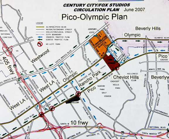
Abstract
The reason for the letter was basically to state that I had nothing to do with the choice if the Pico-Olympic one-way street project and that my corridor would be Venice and Washington for a FB. Pico-Olympic is the wrong corridor because it is widely separated and impacts residential communities so much. The letter became an opportune time to mention a number of issues that had been developing such as 1/ it would be good to rethink the Westside regional employment growth, 2/ become knowledgeable of the traffic context in the Basin generally, 3/ that a FB has many positive characteristics that help communities cope with the traffic and development conditions, 4/ BRT transit on a FB is truly rapid and 5/ a basin loop of FB corridors is a worthwhile objective among other ideas.
Phillip Jon Brown, Architect
1864 Benedict Canyon Drive
Beverly Hills, CA 90210
FLOWBLVD.COM
June 28, 2007
Re: One-Way Pairs
and Flow Boulevards
This letter deals with Westside planning concerns and the Pico/Olympic one-way proposal. The Pico/Olympic proposal is not the helpful improvement the community is looking for. However, the objective of obtaining additional capacity from existing boulevards is the right way to go for Los Angeles.
Everyone on the Westside knows that traffic congestion is impacting our communities and quality of life. This is partially due to the fractured planning responsibilities that have left the Westside with planning deficiencies. There are not only gaps in planning responsibility, the Westside has been neglected and subordinated to a detrimental degree resulting in a lack of problem solving plans.
I think one-way pairs, or the improved form that I call Flow Boulevards (see below), is the only way Los Angeles will get the needed capacity to move people and goods to the places they need to go in our communities. Flow Boulevards are affordable, they can provide a citywide rapid bus system quickly, as well as solve for future vehicular travel demand. They are integral with existing commercial development and finally, they would leave single family residential areas protected from excessive traffic if designed correctly. The best corridors for development simply have to be chosen.
PICO-OLYMPIC COMPARED TO A FLOW BOULEVARD
The Pico/Olympic one-way pair idea is an incomplete concept and that is why the wrong corridor was chosen. It is also the reason the environmental and operational impacts were not seen before hand. Flow Boulevards are more than one-way pairs in that they are a complete environmental and transportation concept deserving the special name. A Flow Boulevard is a technique to impart bound up capacity from existing boulevards and it is also intended as a land use development technique. They work together to develop each other. Briefly, the Flow Boulevard (FB) goes through three stages of capacity increase. If you start with what is presently a typical existing boulevard with 800 vehicles per lane per hour capacity, the first stage of a FB is simply designating the one-way pair and by synchronizing the signals should obtain a 50% increase in capacity to approximately 1200 vehicles/lane/hour. The reason the Pico/Olympic Proposal only got a 6% increase is that it is not a one-way pair. The contra-flow bus lanes on each segment make signalization act as a two way bus street, the cars just happen to be going one way. To further define the FB stages, a second stage would have approximately 1700 vehicles/lane/hour and the third stage would have approximately 2400 vehicles/lane/hour or a 200% increase in capacity over existing average boulevard operation today. Staged capacity growth will allow a balanced management between the FB and protection of the adjacent community to occur. That way the FB grows with the consent and needs of the adjacent community. The second and third stages of the FB development is involved with raising pedestrian circulation across the boulevards to an upper level by way of architecture thereby getting people out of the street so vehicles flow more freely and in the third stage continuously with out signals. The third stage would be many years in the making, because it includes the need for grade separation of major cross boulevards. Therefore some corridors would be many years off (50 years?) from such a third stage. The third stage is in a sense a provision for futuristic possibilities. That possibility may include an all computerized, all electric vehicle operation. The potential would be there because the ROW would be there. A first stage network in Los Angeles however would be a phenomenal increase in capacity in itself and would eliminate traffic congestion for many years.
Continuing with the Pico/Olympic Proposal, the other outstanding problems with it are that due to the wide separation of the “paired” boulevards there is the impact of cut-through traffic. Secondly, due to the fact that Pico is largely commercial with high trip end counts, it generates a high volume of destinations (shopping, restaurant etc.) that requires destined or return trip traffic that also cuts through adjacent residential areas. The generated cut through traffic, the wide impacted residential area between boulevards and the pitifully small capacity increase determines that the Pico/Olympic corridor is the wrong corridor. The corridor at first glimpse seems attractive because it is continuous and has few “road blocks” ( discontinuous streets or narrow roadways). It is upon understanding its operation and the relationships with land use that it becomes clear it has many structural problems. The bottom line is that Olympic having few signals and four lanes flowing west from Century City actually operates fairly well. Leaving well enough alone would be advisable. To turn Olympic in to a really strong high capacity street would take too much development and impact on the adjacent residential areas. There are better corridors that will build a much needed network of one-way pairs, or rather Flow Boulevards (see www.flowblvd.com section LA FB Network).
The Westside Traffic Dilemma
The Westside is the most glaring example of neglectful planning, but there are many other areas of Los Angeles with emerging problems as well. While the MTA has been planning and building for downtown growth, everywhere else has been spawning increased traffic and land use problems. The second, and a most important point is that, planning for transportation and land use have not been planned together. Neglect and inadequate planning leaves the Westside in a state of direr need.
LA City has probably deferred large scale transportation planning to the MTA leaving the LADOT simply with the job of trying to respond to congestion with “traffic management” techniques. The LA City Planning Department operating with a “project” approach simply waits for big developers to propose big plans in order to respond to them. There is no master plan shaping transportation and land use. There is no strong vision of what Los Angeles should desire to become.
The result is that for years the Planning Department has been ineffectual and disconnected with emerging problems. By default, the Westside is seemingly just some suburb that is to take its signals from downtown. Due to this neglect the Westside has inadequate plans to deal with its problems.
Now we can see our freeways at capacity and people trying to use local boulevards to get around. With the SCAG 2030 Projection of a 38% increase in population generally for the southland, you can expect 38% demand growth in practically every other aspect of LA habitat as well; housing, traffic, employment, investment, education, entertainment and so on. We need planning for all of the above, not just some commuter lines that go downtown and may have some speculative office buildings built around stations.
With freeways essentially at capacity and the MTA rail program essentially for downtown benefit, I think obtaining increased capacity from existing boulevards is the only realistic option to provide for future travel demand and to be the structure that communities build and grow upon. Fortunately the Flow Boulevard concept is able to affordably provide increased capacity while developing increased density within a corridor. It is a breakthrough concept for transportation and land use. This technique is capable of giving form and function to communities throughout Los Angeles (see www.flowblvd.com).
Westside Regional Employment Focus
It would be good to rethink the concept of where additional regional employment on the Westside should be located. This has major effect on future traffic flows and potential impacts on residential areas. More dispersed employment areas connected to primary transportation corridors would be a logical premise to guide location. I do not think the City of Santa Monica wants or should have major transportation and development heading its way that would require major access to the far end of the City. And I know that many intervening communities and neighborhoods are already stressed with too much traffic. I would think that a more balanced relationship between additional regional employment would be in the Sepulveda Corridor. That way there is a limited penetration of traffic off the 405 into the Westside. Existing east-west boulevards would handle short commutes from adjacent communities to the east and west of the 405. The area from mid-city LA to Santa Monica was never meant to be a regional employment center so the containment of much of the future growth would be a reasonable objective.
To facilitate this a Flow Boulevard would pick up Westside destined traffic from the 405 in a Sepulveda-Cotner (Sawtelle) FB. So traffic from the 405 would exit and move on to the Sepulveda FB well before the new location for the regional employment between Wilshire and Olympic. This would take locally destined traffic off a very congested 405 and essentially let regional through traffic remain. That would give the 405 a new lease on future abilities to carry regional travel demand that has been projected to increase by 46% by 2025 by Caltrans. More capacity through the Sepulveda Pass is part of this issue and probably requires major construction and structure north of Sunset Boulevard to accommodate future travel demand. I would think a continued FB parallel to the 405 would make sense.
What Communities Need, Westside and Elsewhere.
Part of solving for excessive future transportation demand, other than building more road capacity, is to build housing and other uses near employment so a person can get what they want with one tenth the amount of travel. Cut out sprawl; reduce the suburban commute to downtown model of planning. This means recognizing the inclination for dispersed employment in LA and certainly it means a network of high density corridors with housing, employment, shopping, and etcetera with high vehicular capacity and most assuredly bus rapid transit on exclusive bus lanes. Growth in high density corridors will preserve existing single family neighborhoods as well. The high density corridor with housing should be the approach to concentrate upon, not more suburban sprawl. This is essentially the LA FB Network Plan that can be seen on the flowblvd.com website.
Therefore the need to start planning a network of Flow Boulevards for Los Angeles is really called for. Many have forgotten or never knew that four additional freeways were originally planed for in the west Los Angeles area. They are the Beverly Hills, the Laurel, the Whitnall and the Slauson freeways.
However it is good the freeways were not built in that they divide communities and are quite anti urbane in character. One can understand, however, the deficit in capacity that the west side of Los Angeles is working with. One key fact is important to know here. The optimum speed of vehicular travel where you get the highest capacity with safe head ways between vehicles is at just about thirty nine miles per hour. This as well defines the appropriate character of the FB.
So Los Angeles faces serious growth (38%), and starts with great deficiencies. Widening freeways is a limited option due to acquisition costs and that more than 10 lanes of freeway becomes a dangerous facility operationally. And in many places there are no freeways to widen! The time for Flow Boulevards has come; to get people living near work and to build a most unique urban environment. I believe it can be a most resource conserving city form, an urbane city form that brings life’s positive expressions forward in a safe, aesthetic environment that would be the envy of “old world” cities. Another good feature of FBs is that they can be managed well and can be developed on a where needed, as needed basis, since they grow out of what is already a cohesive street system.
Emphasis can be given to bus transit in a corridor if desired and free flowing vehicular traffic mainly directed to carry local community traffic if so desired. What also seems possible is that the expected increase of 38% in traffic may simply be accommodated as 1/ local community traffic (trips less than 8 miles in length) on newly constructed FBs and 2/ since local traffic no longer needs a place on freeways, the loss of local traffic on freeways is made up by the increase in regional traffic (traffic more than 8 miles in length). In this way the FB network can in effect save the regional freeway system from certain congestion, and may drastically reduce more sprawling freeway construction which would save a lot of country side. What may be more realistic, however, is that “spill-over” traffic from freeways would find there way to adjacent boulevards and your neighborhood. There needs to be a facility that can buffer and direct traffic to appropriate facilities. That is what a FB would be for. Incidentally, the spill-over could turn into a “gusher” if “tolls” or “congestion pricing” where introduced on freeways.
Costs are important because money is limited.
Subway 300 to 400 million/mile
Light Rail 150 + or – million/mile (ROW, hardware and construction costs)
Bus way 90 + or – million/mile ( ROW purchased [orange line] plus busses)
First stage FB 15 to 35 million/mile (signalization, some ROW and construction
costs. Connections with freeways picked up by Caltrans)
Los Angeles needs a rapid bus transit network with exclusive bus lanes combined with housing and new community services. You can see that ten to fifteen times of FB corridor can be built for the same cost of a subway.
Flow Boulevards are inexpensive because you already have 99% of the ROW. The MTA likes to purchase ROW however, so they can have a bullet proof bureaucracy complete with sales tax funding. They are presently 4.7 billion in debt and will pay 360 million in debt service and 229 million in operating losses (subsidized ridership) this year alone. Roger Snoble said that they could possibly complete the building the Expo Light Rail Line but they could not operate it because there is a lack of funds. This is truly a bottomless pit. Their hope is that some day traffic will grind to a halt and people will have to take rail transit. So if we continue with the MTA program it will not only lead to a transportation crises it will impact the economy of Los Angeles. Many people feel it already is a drag on the economy. Suffice it to say, I would look to end the rail program at some logical point and start building the LA FB Network.
Flow Boulevards are not only comparatively inexpensive they promote corridor construction and revitalization. That means you would have new property taxes boosting revenues for the City and County. I would expect that the Network cost would be paid back and that subsequent stages two and three of the FB would pay for itself. With this prospect the sales tax could be eliminated or possibly redirected for other city enhancement.
Some thoughts on Politics
The issue of downtown verses everyone else, in regards to transportation expenditure, has to be faced. But when you think about it, downtown has
practically received everything it has ever wanted; it is every other community that is not doing very well. The budget busting “subway to the sea” is the only real exception that downtown has not received. The fact that subways are essentially unaffordable does not seem to faze them however.
Politically the confrontation should not be so drastic. What downtown needs now is affordable housing (compared with other cities) so businesses can locate here and their employees can find a place to live. The “subway to the sea” can be postponed until there is enough property tax revenue generated by FB development to allow the spend thrift expenditure of a subway. That is what I would tell downtown interests, first housing, and then a subway.
The Westside is pretty healthy, but it needs relief from congestion and an expansion in the type of housing stock so seniors and young people starting out can find accommodations. Seventy percent of population growth is attributable to people living longer and people having children. This would tend to stabilize the communities as well.
In other communities to the north, south and east, FB corridor development would bring about a positive future reversing some depressed areas of our city. The FB would let them get to needed jobs presently out of range. They could then think about affordable housing which would spring forth in the out lying areas that have low land cost but would then be accessible due to better transportation. These areas in turn would produce jobs. I would think that these revived communities become staging areas for constructing the new growth in Los Angeles. Manufacturing of building components is a natural business to develop there.
Get a Good Sense of Traffic Demand
If you have ever seen diagrams of where the traffic demand is you would see that the origins and destinations are pretty much spread evenly across Los Angeles. This is a result of the grid of freeways and roads that structured the building of LA. The radial pattern of rails that the MTA is building and promoting is really simply due to downtown political bias and influence. It is their way of maintaining importance and economic dominance (making big real estate deals).
Regarding the trip demand along the Wilshire corridor (the subway to the sea corridor), downtown has the lowest attraction of trips compared to the mid city area and the Beverly Hills/ Westwood/ Santa Monica area. Trip diagrams will show you that it is a myth that there is strong demand along that corridor and certainly would not come anywhere near justifying a heavy rail subway. As Martin Wachs, the former dean of UCLA’s Urban Planning Department would say, “it is strategic misrepresentation” or in a word lying. I would be glad to show you these diagrams to show you that this is true. Have your Neighborhood Council, service or homeowner group, or Chamber of Commerce contact me to arrange a presentation.
I made diagrams showing all trips in LA County from trip tables from the Los Angeles Regional Trip Study (1990 LARTS); and are probably unique in their kind since most all traffic analysis is on a computer these days (in the black box). The value of graphic representation is that you can see directly the volumes of traffic demand by width of line, where the demand comes from and where it is going. The main use of the diagrams is for designing transportation networks or segments thereof manually. The 1990 LARTS projection is no longer a projection, however the demand districts have not changed radically, they have simply gotten a bit stronger and would exhibit more “sprawl” movement.
FB Corridors to Start First In Building the LA Citywide Network
(Refer to the LA FB Network section on www.flowblvd.com)
So the question in my mind is what corridors should be started first? The Venice/Washington corridor is essentially easy and complete in terms of ROW. Both Venice and Washington are primarily commercial boulevards which is good. However there is a wide separation in a Mid-City portion of the corridor where both Venice and Washington are mostly residential. Here the Lafayette Park residential area off of Crenshaw between Venice and Washington provides the model of what should happen. There is no access from either Venice or Washington. It is a traffic free zone (free of cut through traffic) and has been so for more than 30 years. The difficulty in implementing the FB corridor may be with Culver City politically.
The Western/Oxford corridor has a clean no impact 2 ½ miles between Melrose and Olympic. Not even a parking space would be taken. South of Olympic there would be approximately 16 residential parcels that would need to be taken to provide continuity along the Oxford side of the pair to get to Washington Blvd. Incidentally, this corridor is on the Wilshire Community Plan as of 1975 and is intended as a one-way pair as a result of my involvement with the citizen plan input, from the Wilshire Chamber of Commerce in collaboration with the Citizens to Save the Wilshire District (a homeowner group), to the Department of City Planning.
The Wilshire/Sixth corridor between downtown and Western Ave is an easy corridor. Give downtown some more improvement! Wilshire and Sixth are both commercial streets at that segment and only separated by a single block. This is as close to an ideal condition as you can get, except for possible opposition due to political sentiment. Maybe this is a case where being informative can make a difference.
The Sepulveda/Cotner (Sawtelle) corridor is something that can help out the 405 and lessen traffic impact on residential communities (see above). It also would make planning sense to logically structure the Westside development pattern so it is not over run by speculative development piling on the same areas of
Westwood, Brentwood, Wilshire and the City of Santa Monica. An improved connection to the Valley is also a part of solving problems for this area.
The Santa Monica/ Fountain (and others) corridor from Glendale to the City of Santa Monica is a corridor that should be patched together to better serve the adjacent communities. The objective would be to get three lanes plus an exclusive bus lane each way in this tightly built up corridor that also has “route continuity” flaws. If only three lanes are possible to fit in, where a bus would have to share a lane with free flowing vehicles or having two lanes of free flowing traffic with an exclusive bus lane; even that would be a worthwhile objective to provide service. Differing capacities along the corridor is also an option as long as bottlenecks do not become unreasonable. The travel demand in this corridor is evident and the demand for high density land uses may be the “resource” to tap. Specialized high density projects may afford the necessary three dimensional organization of urban elements (which include traffic movement) that would make it all work. Another potential specialized project might be along Beverly Hills demonstrating the first “tunnel” solution for connecting through traffic from West Hollywood to Century City.
As you can understand by the above, some of the Flow Boulevard improvement is easy and some of it would be difficult. I believe however, it is the method that can bring the desired Los Angeles that is affordable and works with the future trends the city faces. I would expect that in twenty five years half or more of the vehicles on the road will be some form of electric vehicle. I would expect that an increased appreciation for denser urban living would exist and that short trips would be made in a rich urbane environment where education, work, family life, entertainment and cultural expression are a part of normal everyday living in LA.
I hope these thoughts help with your decision making. If I can be informative with additional explanation of these ideas please contact me. I know that a lot of these ideas are unfamiliar. I would appreciate the opportunity to respond to your questions.
Sincerely, Phil Brown