FLOW BOULEVARD
Stages of a FB to FB Intersection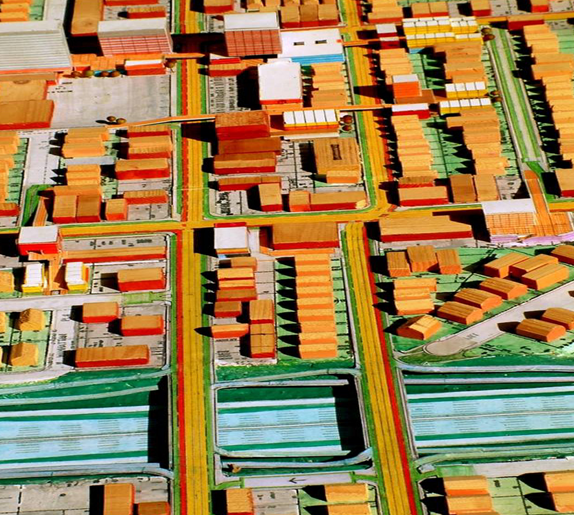
Abstract
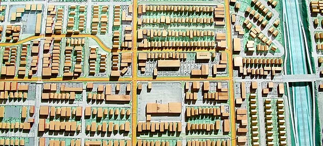
Shown in model form the two proposed Flow Boulevards to study how an intersection would be developed are the Western Avenue FB intersecting with the Venice/Washington FB. This is essentially to show the first stage FB condition, which is grade level based, using traffic signals governing pedestrian and traffic operations. Then higher density becomes the impetus for the evolving of urban elements with three dimensional urban design organizations that bring the benefits of second stage development. This clearly shows how elevated pedestrian circulation, in this setting of increasing density, will not only allow smooth flow of vehicular circulation but also the development of a much desired pedestrian circulation and open space system establishing a rich urban experience. (Comments made in 2007 follow)
FB ELEMENTS AND TRAVEL DEMAND
(November 14, 2007)

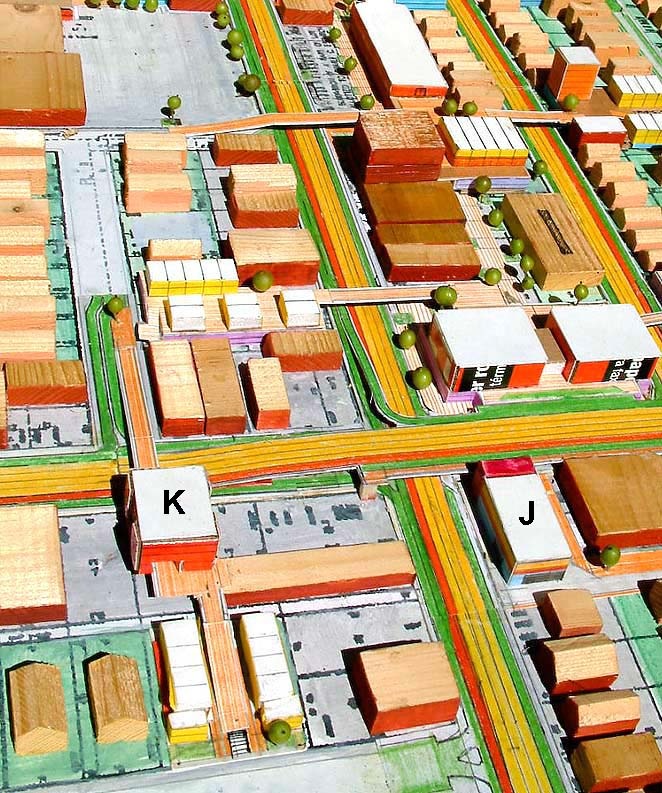
FB Intersection: This model photo is of an intersection of two proposed Flow Boulevards (the Western-Oxford FB and the Venice-Washington FB), where in Stage Two they would be grade separated. For approximately twenty years or so during Stage One, the Flow Boulevards would be at grade as the streets are now with signals controlling traffic flow.
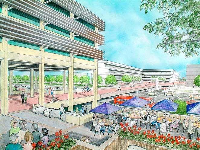
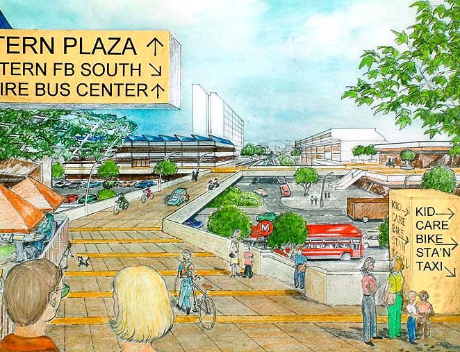
Portal and Pedway: The building on the left acts like a portal opening to the pedestrian circulation environment beyond. The building may very well be in air-rights over a portion of an unused local street at the Flow Boulevard edge. New housing and businesses create higher density settings where the combination of FB, Pedway and Portal become high activity areas where people meet, do business and engage in urban expression.
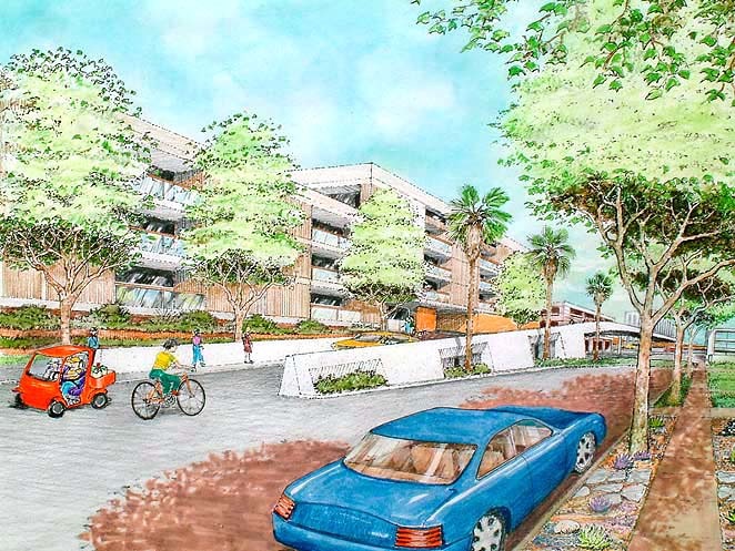
Ramp to Pedway: The edge of the Flow Boulevard corridor is controlled so as to keep unwanted traffic from spilling over into the adjacent residential area. The ramp is for pedestrians, bikes and small electric vehicles to cross from the residential area into the higher density raised pedestrian environment and across the FB itself.
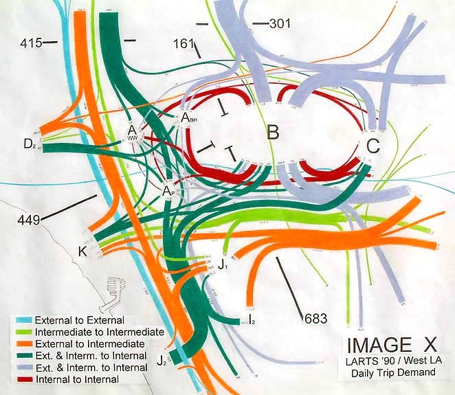
Image X diagrams abstractly travel demand (desired movement) in the west LA area between downtown (on the right) and the 405 area (on the left). The analysis stated in the Travel Demand section below, shows that two east-west Flow Boulevards solve for future travel demand whereas a subway and light rail line do not.
PREFACE
The first and last portion of this new section of the Flow Boulevard (FB) website gets into the elements, or the architectural scale of how to develop FB corridors. The elements that are comprised of housing, roadway and community land uses, will illustrate that they are needed in LA and create desirable environment. The middle portion is the travel demand analysis that shows the FB concept is not only affordable it can provide for future 2030 travel demand and beyond, where current rail planning cannot. The portion of travel demand that the Westside of LA would accommodate is in response to the Southern California Association of Government (SCAG) 2030 population projection for the Southern California region.
Even if the “subway to the sea” and the Expo Line were affordable, and they are not, they do not solve for the anticipated travel demand on the Westside of LA. In fact, if those rail facilities were built, and both of them will not be, it would result in overall Westside transportation system imbalances and deficiencies making a traffic nightmare and an economic disaster. I mention the rail situation because the Flow Boulevard proposals are in direct opposition to the MTA rail expenditures at this time. The subway may not be built for thirty or forty years from now and it will take revenues from Flow Boulevard development in order to pay for the subway. So build a network of Flow Boulevards first, along with much needed housing, then later think about what to pay for with the new FB tax base and the revived LA economy.
In getting into the elements of the FB, an emphasis will be made that the Flow Boulevard concept is a transportation and land use concept. Transportation improvement leads to environmental improvement which leads to transportation improvement and so on through three distinctive stages. The first two stages will be dealt with here, the third at a later time.
Organic community growth and environmental conserving city form are two major issues that should be remembered. Flow Boulevard development in a community is largely organic growth, coming for and by the community. Land use investment and improvement is directly tied into transportation improvement. New jobs, housing and businesses build a better community and continue with the prosperity that well functioning communities provide. Organic applies to seventy percent of the population growth of a community as well, where people are living longer and more people are having children. The environmental conservation of Flow Boulevards takes place at many scales. Flow Boulevards will greatly reduce sprawl by creating growth in corridors within the existing city. They will reduce the length of travel thereby saving time and fuel. A great many resources from building and maintenance materials to water conservation, will be saved by not paving over the countryside with low density development. In my way of seeing the future, urban lifestyle will be a more appropriate way to learn and live than suburban lifestyle. The cityscape will develop university campus like characteristics and support the expression and purposes of modern life.
Note: If you are not familiar with the Flow Boulevard concept, read or skim the following on this website; a/ How the Flow Boulevard Works, to understand the one way pair operation, b/ An Open Letter to Westsiders, for “context”, and c/ Introduction, for overall context and objectives.
STAGE ONE
The Flow Boulevard Begins By Having the Right of Way
The simple objective of this section is to sketch out how to develop FB corridors. Focusing on elements or prototypical units of development, an ABC’s of corridor elements will be shown. Before that however, some background is offered.
The Flow Boulevard concept is a transportation and land use concept, one helps develop the other and vice versa. The chosen corridor is a commercial corridor where development is desired and transportation access is essential. By pairing adjacent parallel streets and designating one way travel, the basis of obtaining increased vehicular capacity from existing street right of way (ROW) is achieved. By designing and building additional land use growth with raised pedestrian circulation that allows crossing of the Flow Boulevards without signals, this will in turn provide for the basis of obtaining yet further increased vehicular capacity from the FB. This process develops over time where travel demand and land use growth are to be kept in balance.
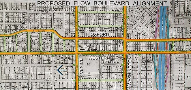
Many corridors are without ROW discontinuity, such as with the wide and continuous Venice and Washington Boulevards which are paired in this study. In other FB corridors one of the streets may not be continuous, such as Oxford Avenue also in this study. One purpose of this study is to look for the problems to be solved. Below it will be shown that elements A and B help establish the Western FB by providing the necessary continuity of Oxford ’s ROW.
Establishing the continuity of the paired streets and synchronizing signals for traffic flow will give improved access with little community impact for years of land use growth. It should be noted that the Western Avenue FB section of this website is a study that shows the ease of development between Melrose and Olympic because there is continuity of ROW.
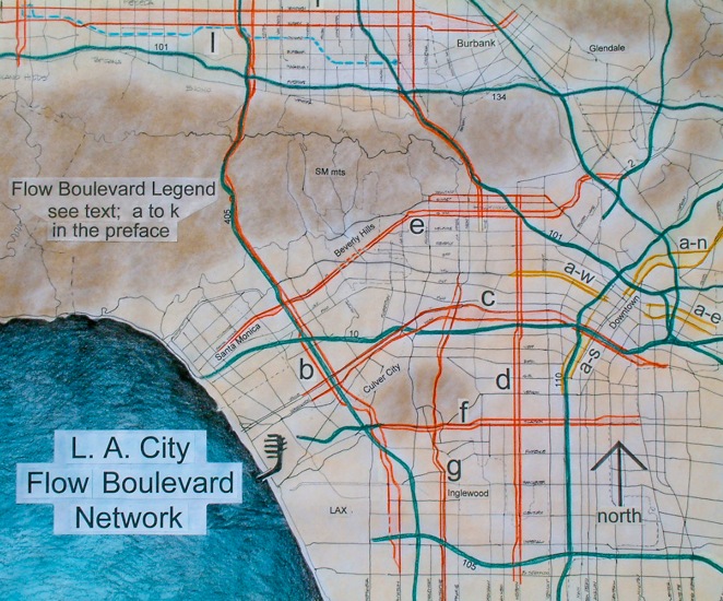
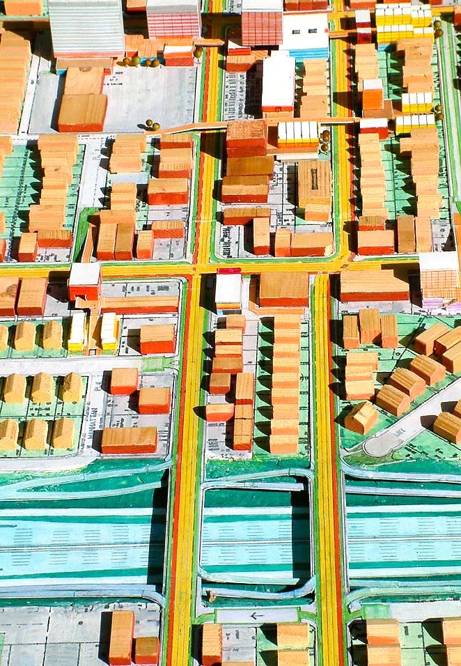
Less Than Two Miles Studied of a Citywide Network
The model in this study just covers a one half of a mile by a mile and one eighth area. This is the intersection of two proposed FBs, the Western and Oxford paired Avenues (W-Ox/FB) and the Venice and Washington Boulevard FB (V-W/FB). On the LA FB Network section of this website is proposed a 135 mile network of FBs. Approximately 115 miles of the system are through existing developed area, the remainder through the Santa Monica Mountains or like minimally developed terrain. Though the study is of a small area it is to address the issues of the larger area as in generic solutions.
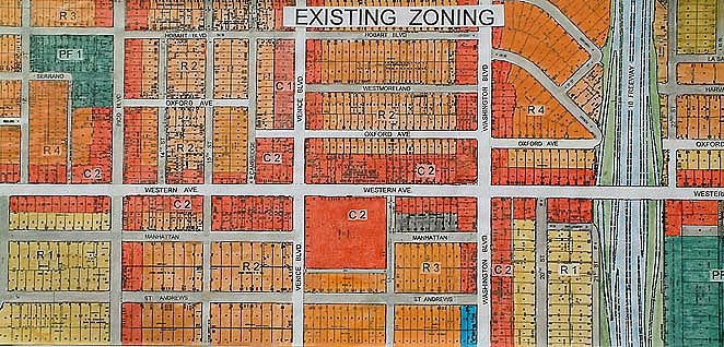
Model Representation: It would be good to explain some of the symbols used in the model before going further. Regarding the lanes in the FB itself; the yellow lanes are the flow lanes for mixed vehicular use, the red lanes are the exclusive bus lanes in the FB, and the green lanes are for merging in or out of side streets and for street parking. Existing city blocks and streets are easily picked out as is the 10 freeway. The blocks of wood on the model represent existing development, where as the white roofed building represent newly developed elements associated with making the FB system work and evolve. The coloration follows traditional zoning representation where red is commercial (C-! & C-2), orange to light yellow is residential (R-4 to R-1,) and blue are for various institutional uses.
Stage One Flow Boulevard: More than likely a Stage One Western-Oxford FB would end at the Venice-Washington FB (Washington running vertically on the right). A Stage “One and a Half” would see the Western –Oxford FB continue south by bridging over the 10 Freeway.
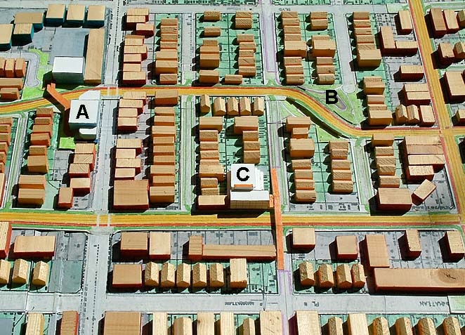
Elements A and B brings continuity to the Oxford ROW (right of way). This allows the one way pair traffic operation of Western and Oxford to work. Element C begins land use redevelopment and the beginning of the elevated pedestrian circulation system instrumental to Stages Two and Three later.
The Study Area is a small area of the proposed Flow Boulevard Network (see the LA FB Network section on this website for further description). Growing out of the existing street network, the higher travel capacity and higher population density FB corridors develop over time. Many corridors would be at the stage one level of development without much grade separation for many years.
Density, Higher Capacity, and Walking
The basic transportation problem of congestion is due to not having adequate capacity in our transportation facilities. The basic need of course, is to provide for the travel demand with adequate capacity in a given corridor and the network as a whole. The Flow Boulevard concept develops a breakthrough in the congestion quagmire because it is capable of doubling, tripling and even more the capacity of existing boulevard ROW. The FB transportation facility would fit between that of a regular boulevard and that of a freeway in the hierarchy of roads and capacities. It is an appropriate transportation facility because it becomes part of a high density land use corridor and will not breakdown in congestion as regular boulevard development is inclined to do.
By growing a FB network out of a network of regular boulevards, continuity of existing development with future development is secured. By the ability of Flow Boulevards to increase capacity into the future, it gives adjacent land use a promising future as well. So it should be recognized that the FB concept is a land use breakthrough concept for building the denser corridors that are needed to accept the growth of efficient city form. This is how the existing portions of Los Angeles can accept the 38 percent growth of population, housing, community services, institutions, employment and traffic that SCAG expects by 2030. Well don’t panic. If it is reached by 2040 I would be surprised.
Surprisingly enough, the increased travel capacity and land use growth is based upon the ability to provide circulation and open space for the pedestrian. It is a bit ironic, that the solution to travel demand and growth is to provide space for walking but that is one of the main reasons that make the FB system work.
To get higher vehicular capacity from existing ROW, the less vehicles have to stop to let pedestrians cross the street, the more flow can be given to vehicles. The safer, more pleasant and greater pedestrian circulation and open space is, the more attractive development of land use occurs. It is more attractive for people and land uses to be there. This becomes the function of the elevated pedestrian circulation and open space system woven through the FB corridor.
Less Than 600 New Housing Units per Mile
The small elements of corridor development shown below will add up over miles of corridor establishing a new environmental quality to Los Angeles . Traffic free pedestrian circulation, neighborhoods and open space are the objective. In the LAFB Network section, I derived and distributed along 90 miles of FB corridor approximately 80 percent of the expected new housing that would be expected to house the 1.2 million person increase SCAG is projecting for 2030. Criteria for this heavy distribution to corridors was so there would be preservation of existing single family housing communities. The distribution became 3600 new dwelling units per mile, or in another description, one new unit every sixteen inches. Well you will be pleased to hear that the FB system will need less than 600 to bring FB operation to the Stage Two level. In this lower density eight feet apart on average is not a bit close because high density housing is stacked and spread across the several blocks comprised in the FB corridor. You will see this in the model. Greater density is certainly possible and likely given the attractive qualities of village like pedestrian neighborhoods for seniors, singles, couples and families. More density spread laterally beyond the corridor, but in walking distance, is also expected.
Affordable New Urban Environment
With many FB corridors being built, along with the rapid bus exclusive lane bus system able to reach out to where the land prices are low, this should create a competitive market that will bring affordable housing to Los Angeles . With a rapid bus system able to link affordable housing to a growing job market, both centralized and dispersed, the necessary connection is made. Affordability for the public budget is also seen. With first stage FB costs averaging in the 20 million dollar per mile range that is much lower than rail costs in the 180 to 480 million dollars per mile range. With new density being built, and sale and purchases of existing properties, a new higher level of tax base is attained. A new affordable urban environment should be attainable by structuring a citywide network of Flow Boulevards.
Community Participation and Negotiation
Two groups will lead much discussion regarding the community welfare. The Chamber of Commerce and the emerging Neighborhood Councils throughout Los Angeles should focus on development issues and give continuity from the existing situation to the new urban environment. Development activity should be active with small and larger development. Further thoughts have already been set forth in the Flow Boulevard 2006 section of this website.
Stage One Capacity Increase for the Flow Boulevards
To summarize the expected stage one vehicular increase over the existing travel in both the W-Ox/FB and the V-W/FB corridors finds a 100 percent increase for both of them. The existing Oxford Avenue through-put is negligible. There is some congestion relief at locations such as at Oxford and Wilshire that has signals, but being a residential local street it is not set up for medium length travel through the Wilshire District. Therefore existing Western Avenue with just two lanes north and two south will show a dramatic increase for the corridor when the first stage FB is established using Western and Oxford Avenues in a one way paired configuration.
The present volume of traffic on Western Avenue at Wilshire is 36,000 vehicles per day and about 31,000 through the Venice and Washington intersections. With a stage one Western FB established, having 3 lanes south on Western and 3 lanes flowing north on Oxford utilizing synchronized signals will expectedly give 1200 vehicles per lane per hour times six lanes times 10 ( the factor used to approximate average daily travel) equals 72,000 vehicles. This is a 100 percent increase over existing usage and then you would add bus ridership above this amount due to the rapid bus transit on exclusive lanes.
The existing daily volume for Venice at Western is 23,000 vehicles per day and for Washington is 23,600 totaling 46,600 for the two of them. This would be less than 600 vehicles per hour per lane at peak hour. There is additional capacity in the existing boulevards, but in any event with synchronized signals of eight lanes of first stage FB (4 lanes east on Washington and 4 lanes west on Venice) this would give; 8 lanes times 1200 vehicles per hour (peak hour) times 10 hours equaling 96,000 vehicles for an average day in the corridor. This is a 100 percent increase over the existing condition without counting the additional person trips on the rapid bus exclusive lanes.
Organization of FB Elements
It would be helpful to insert within the discussion of the elements themselves, how they would be spaced and their relationship to cross streets. Again let me refer to this website section, How the FB Works ,for other functional relationships.
In the study area shown on the model, east-west major arterials are spaced approximately every quarter mile. Built up through stage one would be elevated pedestrian crossings (pedways) of the FB occurring at maybe a quarter mile spacing. The existing grade level pedestrians street crossings at signals would still be the basic system for the FB during stage one. The elevated crossings are simply anticipating the eventual stage two and three pedestrian circulation where elevated circulation predominates. In stage two there would probably be pedways at spacings of from an eighth to a quarter of a mile (660 ft. to 1320 ft.). In stage two the elevated pedestrian circulation system is not complete but it would allow certain signals and cross traffic streets to be removed so the FB operates more freely and at higher capacities. Stage two vehicular capacity on the FB would be in the 1600 vehicles per lane per hour range. At stage three the spacing of pedways would be from one sixteenth to one eighth of a mile (330ft to 660 ft.), and the vehicular capacity per hour per lane would be in the 2400 vehicle range.
You are really going to have to read the text to understand what is going on here. This is new urban environment developing in the higher density corridors in the future Los Angeles.
The spacing of pedway crossings will relate to the adjacent land use and the general density and spacing of arterials that will cross the FB. In the Mid-City area, as mentioned above, with major arterials at quarter mile spacing, they will all need to be grade separated by stage three or made to operate well at a stage two condition, and not all grade separated. Stage three has continuous flow of vehicles, no signals. I would expect the Venice – Washington Flow Boulevard to eventually develop to stage three in that there are fewer major cross streets.
To the west, away from downtown, major arterials occur at one mile spacing with secondary arterials or local collector streets between them. So there would be probably half the number of FB and cross street grade separations and half the number of pedways per mile as would be in the east.
Remember that in the city wide network, at any given time, there may be many different stages of FB development. It can be understood that some areas will never be stage three or even stage two. This would certainly be the case at the fringes of the city, but it is also possible that there are simply low density and low trip attracting areas that do not warrant higher capacity facilities.
From the transportation management view, major routes of travel demand would want to receive the land stimulation to bring the desired stage of FB development with the amount of capacity to accommodate that travel demand. In the middle portion of this new section, travel demand is explained for the Westside and a 2030 projection is made. A resulting FB capacity range is established with the required stage of FB development for two east-west corridors. A stage one FB is selected for the Santa Monica corridor and a stage two FB is required to meet the 2030 travel demand in the Venice-Washington corridor.
List of Elements
Elements A and B will be used to obtain continuity for the Oxford Avenue portion of the Western FB.
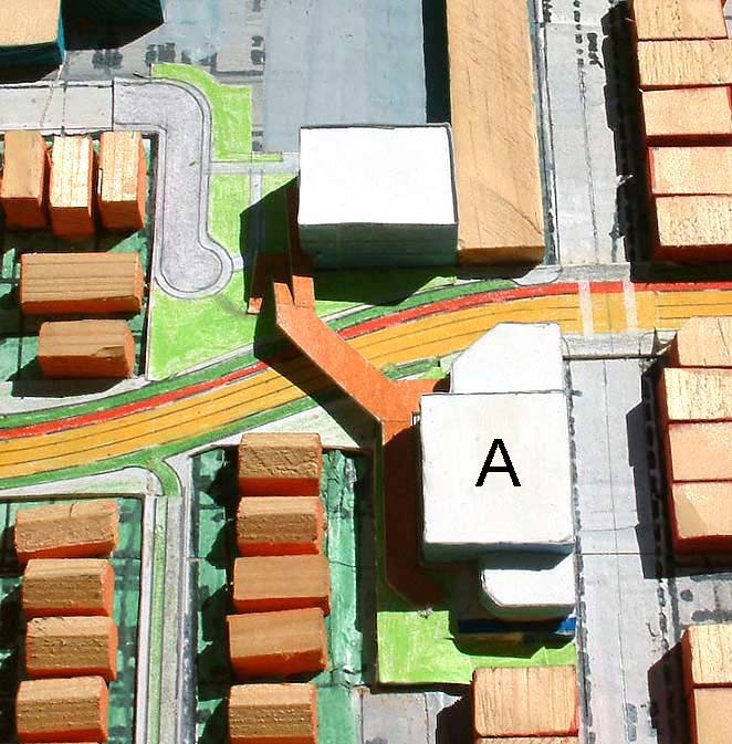
Element A is partially a school expansion project. The necessary existing parcels to connect Western Avenue providing an acceptable flowing curve is combined with an expansion of the existing school to the east with a pedway across the FB to a new air conditioned school gymnasium over parking. The parking is an investment in the area to provide parking where there is little on-street parking. The style of combining functions is intended to solve for a number of needs in an area. This may lead to Joint-Ventures, condominium ownership of property or entrepreneurship by a developer to serve a need.
Element B is a park project combined with the aligning of a part of Oxford Avenue . Again parcels are taken, in this case 8 parcels. Obviously this is not the only choice of alignment. This would require a study in itself to see what would be the best solution. It can be said however, that from Melrose to Washington Boulevard would be three and one quarter miles, and to only have to “take” a total of 18 parcels is in no way excessive. The economics are reasonable and the social dimension can be made to be equitable. The growth of a community is in effect, dependent on it.
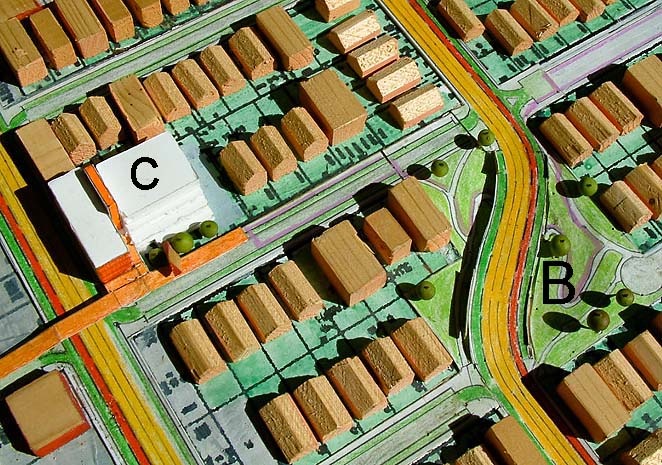
Element C is an example of a standard pedway crossing a FB from an adjacent residential neighborhood over to a primarily commercial set of blocks. It would be anticipated that due to the high degree of accessibility of the commercial blocks there will be new construction that would occur that would develop the raised pedestrian circulation and open space system. Zoning and building incentives would help stimulate that environment. In the particular instance of this element C, a combined new commercial office and terraced multi-residential building over a raised platform of parking replaces an existing auto repair shop and out of date residential court land use. Generally, off setting the cost of pedways (the elevated pedestrian bridge) is the raised platforms of parking. By not having to dig down deep making subterranean garages, the savings in smaller retaining wall, ramping systems and water proofing costs allow the savings to be allocated to pedestrian circulation.

Ramp to Pedway
The perspective showing a nice wide ramp is meant to capture the edge condition occurring along the FB corridor. One objective is to provide pedestrians, bikes and small electric vehicles access over the FB. A second objective is to protect the existing residential area from a possible over flow of traffic from the increased traffic in the emerging FB. Traffic could be completely blocked off or limited in some way, only allowing traffic to exit from the residential area for example. Access to commercial land use along the face of the FB may occur on the FB or from behind as in an alley. Many relationships are possible regarding use of the ramp, including who constructs it and when. Standards will want to be evolved and I would think the Chamber and the Councils will help in that regard.
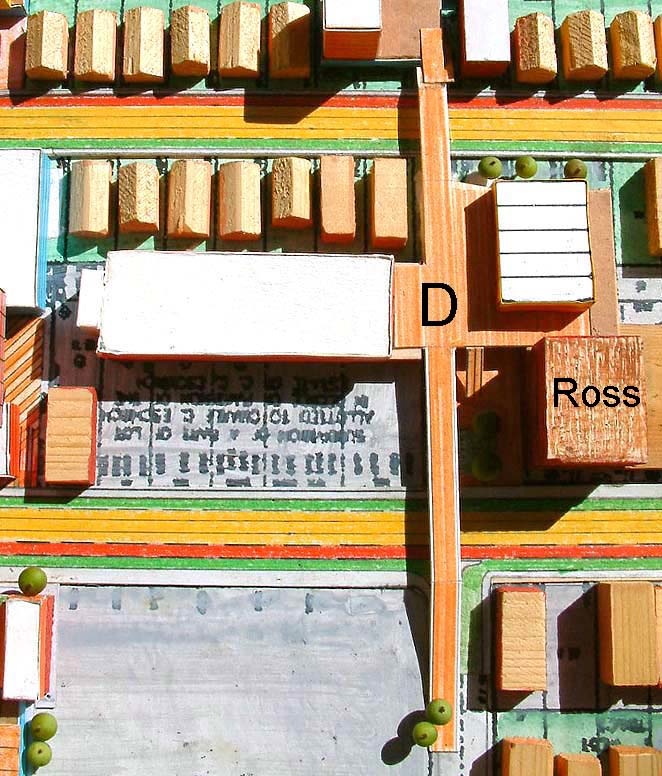
Element D is yet another composite of activity involving existing commercial land use. The element of D is the recognition that remodeling and addition work to existing structures will happen in abundance. That these activities include the development of the pedestrian circulation and open space system is the point to be made here. The existing (Ross Plaza) tower would refurbish and use an at grade parking area to develop a multi level parking facility to serve additional office space and a townhouse residential project on the top deck that also extends the raised pedestrian circulation eastwardly. This would continue the ramp and pedway crossing made over the Western avenue portion of W-Ox/FB. The additional office space would be a second story addition over the existing strip commercial retail that will tie into a continuing at grade level mall to emerge through the center of the block running north and south.
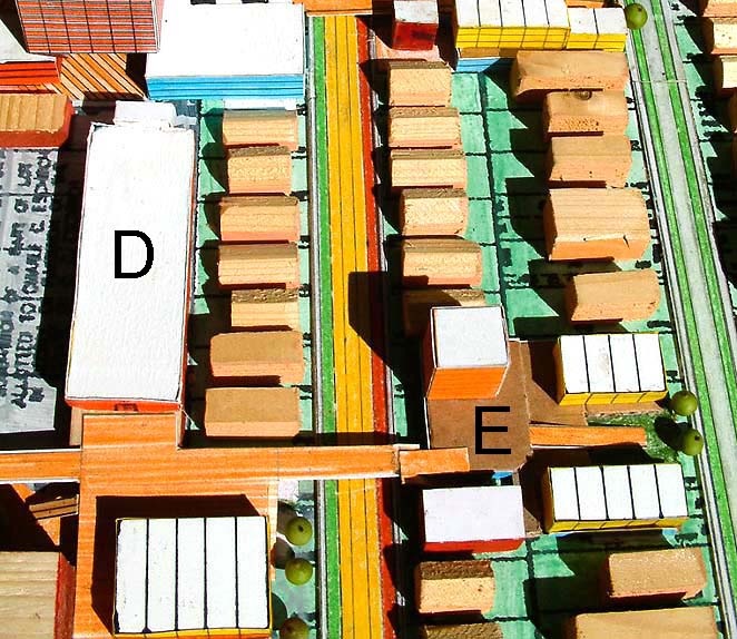
Element E is described as a typical new residential project (townhouses in this case) over parking development that incorporates some small convenience commercial at the Oxford frontage and a small residential tower (maybe senior). The multi level parking slopes so the townhouse parking enters from the easterly Westmoreland side going up, and the commercial and tower parking enters from the Oxford side going down below the residential parking. The sloped parking structure provides the pedestrian circulation on the structure top deck an incline down to the Westmoreland neighborhood at grade. This is an economical organization of functions and unites the different levels of environment. The pedestrian circulation, or what can be called a pedestrian street, recalls the Philadelphia Society Hill or the Boston Beacon Hill pedestrian scale of environment. This is your urban village neighborhood where walking connects you to community services and transportation.
10 Freeway FB Connection
The freeway system and the FB system will develop a very meaningful reliance on one another in the future. The freeway system with long and medium length trips at present will, in effect, specialize and become primarily a long trip facility where the FB system will be primarily the system to carry medium length trips along with regular boulevards. The breakout by kind of trip, volume, length and destination, will be shown in the following travel demand portion of this new section of the website. It will be shown that the specialization that is referred to fits very nicely regarding the expected 2030 travel demand. Generally the FB system will be picking up the future growth in terms of population and traffic citywide. Flow Boulevard corridors are growth corridors.
What may be called stage one and a half, in regards to the Western FB, is when Oxford is given a bridge over the 10 freeway, connection ramps to it and thereby extends the FB southerly. As shown in the Western Avenue FB section, the Western FB is intended to eventually extend to the 105 freeway. It should be noted that it will be a common occurrence to have a FB end and blend back into the existing grid while development and travel demand in the intended corridor is building. In the case of the model here, the Western FB will end at the intersection with the V-W/FB until the bridge can be built.
STAGE TWO
Pedestrian Grade Separations, Cross Streets and Other Flow Boulevards
Stage two can simply be defined as a development stage of the FB when there are a number of elevated pedestrian circulation elements taking place and maybe some key grade separations of cross streets being built. In the model shown in this presentation, the intersection of the two FBs is clearly a stage two event. Venice and Washington Boulevards will rise and cross over Western and Oxford Avenues (element O below). The shorter raised street choice, rather than Oxford and Western going over Venice and Washington , will have less impact and expense.
The issue of grade separation elements does bring up the issue of what is the basic need and what amount of development is likely to accompany corridor growth. With large amounts of land use development it is conceivable that almost anything could happen, so to speak. What makes the transportation increase in capacity difficult is when there is little land use development to go along with transportation improvement. Yet as a general statement, it is reasonable to expect that if there is little up grading of land use and density, there will be little demand for transportation improvement.
The extremes of this issue will present challenges to FB development. The extremes being, a/ in areas that are already highly developed where little obvious additional development that would incorporate FB elements, and b/ where a depressed area of under development would not seem able to attract development incorporating FB elements. In both of these conditions extra creativity will be needed as well as the learned benefits that naturally spring from FB growth.
Opportunities and necessities are being explored in this study. The focus is on the architectural scale in relation to transportation travel demand. I hope the message is getting across that they not only help develop each other, higher capacities to move people and the denser urban neighborhoods are needed to be developed together to accommodate growth in Los Angeles. In this probe into the future, a small amount of development is being assumed to express the essentials that are needed for corridor growth. About 600 new dwelling units per mile is what is being shown in the model. I would think that once the benefit of the FB approach to corridor growth is understood, there will be a great deal of interest and development to accompany transportation improvement.
Most of the land use elements presented here are involved with incorporating the elevated pedestrian circulation that anticipates the much higher FB pt capacities in stage two and certainly stage three. The following are descriptions of land use and transportation FB elements.
Venice Grade Separation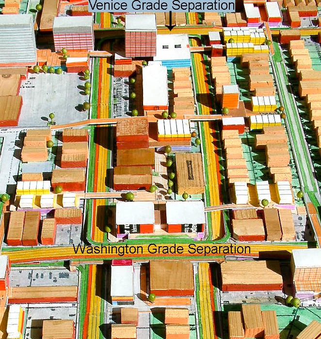
Stage two can simply be defined as a development stage where there are a number of elevated pedestrian circulation elements having been built or are being built along with some key grade separations of cross streets. In the model shown in this presentation, the grade separation of the two flow boulevards (Western FB and V-W/FB) are definitely stage two activities.
Venice and Washington will rise and cross over Oxford and Western Avenues (element O below), in this case, in that it is the shorter raise street alternative having less expense and impact. Grade separation does bring up the question of the expected amount of development to accompany FB road improvements. With large land use development it is conceivable that large amounts of grade separation including roads and pedestrian circulation would be taking place. The new larger land use with larger travel demand would find justification for the grade separation improvements. In the case of an intersection of Flow Boulevards the corridor travel demand would justify the grade separation. Therefore attention to developing the whole corridor in a balanced way is an important planning activity. What makes the transportation side of corridor growth difficult is if there is little land use development to go along with heavy travel demand. Yet as a general statement, it is reasonable to expect that if there is little up grading of land use, and accompanying travel demand, there would be little demand for transportation improvement. In a way, the large travel demand anticipated by this study, in response to the large population growth anticipated by SCAG, is stating very clearly; denser land use development in improved transportation corridors is absolutely necessary. What the FB system is doing is showing how it should be done.
To further deal with the issue of the amount of adjacent land use improvement, two challenging extremes are posed. The extremes being a/ in areas that are already highly developed where little obvious additional FB element development seems feasible and b/ where a depressed area of under development does not seem attractive to development. In both these cases extra creativity will be needed as well as the learned character of opportunities that naturally spring from FB growth.
Opportunities and FB necessities are being explored in this study. A probe into the future is being made with urban design and in this portion focusing on the architectural scale to present “feasibility”. FB elements are made of new relationships of known existing architectural, pedestrian and vehicular circulation as well as open space elements. The skeletal “look-see” of what a FB corridor is comprised of continues.
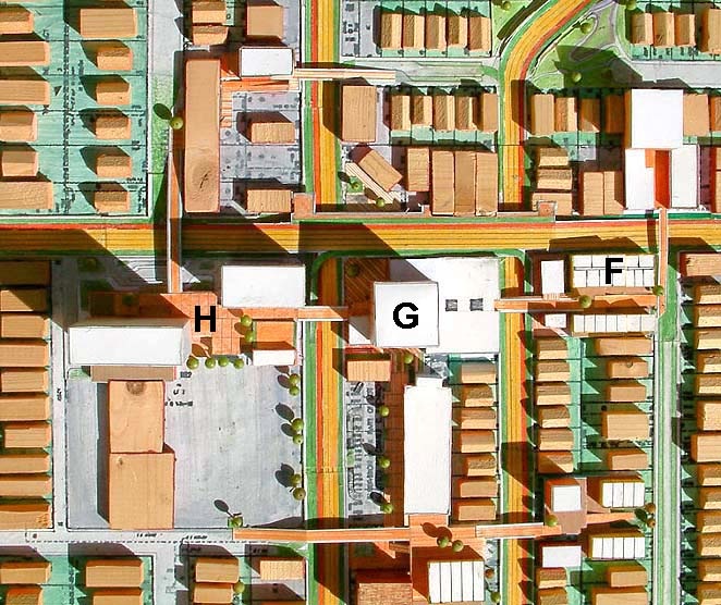
One of the most development dependent elements of the FB system is the elevated pedestrian circulation over the Flow Boulevards and the connecting to the grade level pedestrian circulation beyond. To clarify the intended use of the word element would be helpful here. An elevated pedestrian circulation pathway is a FB element, but so is a land use development that incorporates a portion of an elevated pedestrian system. Land use elements like F, G & H that contain a portion of the elevated pedestrian element running east – west connecting the blocks adjacent to Western and Oxford Avenues, are elements in themselves. Saying there are circulation elements and land use elements is a bit two dimensional. That is why a land use that incorporates circulation, and these new relationships, that makes the FB system connect is a FB element. Where as a land use construction that did not make the FB connect and work would not be a FB element.
The elevated pedestrian way connecting F, G, & H, will be required for pedestrian connection when Western and Oxford no longer have signals to stop traffic allowing pedestrians to cross the streets at grade. At that time, in stage two, Venice and Washington will be grade separated crossing over Western and Oxford , also without signals allowing free flow of traffic. It should be mentioned here that this is when the higher vehicular capacities are being obtain from the existing ROW. A stage two flow lane on the FB is able to have in the vicinity of about 1600 vehicles per hour, double what you would find on a typical regular boulevard today.
Element F: Element F would be similar to element E except that being next to Venice it will need to anticipate the grade separation construction of a raised Venice Boulevard. Until that time signals at grade would control Venice and Oxford traffic. At the time of grade separation both Venice and Oxford will have no signals. Pedestrians moving east and west from element will use the elevated pedestrian circulation. Pedestrians moving north and south from element F can continue to use grade level circulation in that to the north pedestrians will simply circulate below the free flowing Venice Boulevard above.
It should be said that the new residential and commercial development of element F is not a “must be” land use. The existing one and two story commercial buildings could be “adapted” to a mall at grade condition oriented in the middle of the block. This may conform to the property owner’s preferences or an economic reality. In that instance there will still be the need to have an elevated pedestrian crossing over Oxford and possibly a ramp or other arrangement to connect to grade level. Pico Boulevard to the north may at some point need to be grade separated if travel demand and corridor growth require, so as not to breakdown in traffic congestion and stifle desired land use growth. The reorganization or new organization would depend on real estate opportunities and economic realities at that time. There are however options in the middle which could favor evolving and adapting as time wore on. Again, there are thoughts in the FB 2006 section of this website that consider notions of “block corporation” that deal with changing conditions and development opportunities.
FB Turning Movements at a Typical FB Intersection Corner
It is best to interject this aspect of vehicular movement as the elements are being built up. In stage one at the corner of Oxford and Venice prior to the event of grade separation, traffic signals will allow pedestrians to move across these streets and signal operation will direct the turning movements of vehicles. It is obvious that turns into one way traffic will not be allowed, but there will be a right turn from east flowing Venice to north flowing Oxford and a left turn from Oxford to Venice when signals permit. In stage two when Venice is raised to go over Oxford so both of them can flow without stopping, these same turning movements would continue to exist but with different conditions. The additional condition of ramping up from Oxford to Venice (from flow lanes to flow lanes) will be made by use of the right merge lane on Oxford to the up ramp to the left merge lane on Venice and on west on the Venice flow lanes. The right turn from Venice to Oxford still occurs at grade, probably with a signal or stop sign. The left turn at grade from the left merge lane would now turn on to the street below Venice that not only connects over to Western but is a place where various modes can exchange passengers and there would be places for waiting taxis, buses and storage of bicycles. So with this explanation it is understood that the left turns at grade at each corner allow a driver to go completely around the block or to reverse direction on a FB. Someone that understands that the up ramps and down ramps that connect FB to FB will also allow a driver to make left turns at each corner and completely circle around the block. But this will not be allowed because it is too much fun.
To relate pedestrian movement to these corners; essentially movement at grade along either side of both Western and Oxford in a north – south movement can occur at each corner, but not across Western or Oxford at grade because the traffic will be flowing without stop. Conventional stop signs or signals will control pedestrian and vehicular movement for the north-south pedestrian movement. This condition is worth emphasizing because a pedestrian can walk at grade from north of Venice to south of Washington if they are not to cross Western or Oxford . The east-west pedestrian movement that crosses Western and Oxford will be taking place at the elevated pedestrian level. This same condition essentially occurs at each corner of the center block of the FB intersection. As will be observed with Elements K and I (just south of Washington) and Elements R and Q (just north of Venice) crossing Venice and Washington away from the intersection corners to go north and south will require elevated pedways where Venice and Washington have returned to grade level.
Element G: Given the high degree of accessibility of the central block of the two intersecting Flow Boulevards a more major land use is anticipated. Building on a theme of medical services in the area a medical tower with commercial retail has been posed along with the elevated pedestrian east – west continuation over Oxford and Western. Below the tower is a plaza at grade that continues the emerging north-south mall. There would be an escalator and elevator connection between the elevated and at-grade pedestrian circulation at this point. An interesting point to consider is that the north side of Element G will have a two level Venice to interface with. This may mean conditions for goods delivery and pedestrian transfers of modes at grade level: where as the upper level may allow specialized arrival connections.
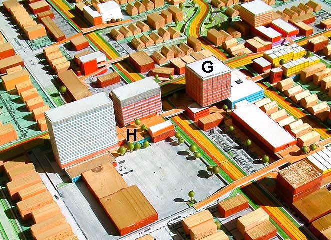
Element H: Element H is a full expression of the medical theme for the area. Here some kind of medical services tower is shown next to a medium sized hospital. Parking levels support elevated pedestrian plazas and continue the pedways across the Western FB. Elevation changes to grade are provided to connect to existing development. A pedway will cross Venice and ramp down to the neighborhood to the north. The F, G, H elevated pedestrian way allows connection of all the blocks south of Venice when the signals at Western and Oxford are removed. A loop of pedestrian circulation is developing around the intersection of Venice with the Western FB. Additional elements described below will complete this loop.
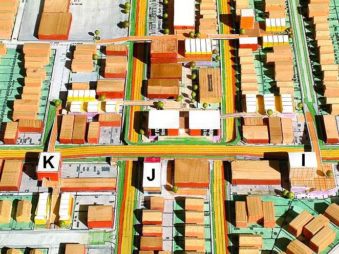
Elements I, J, & K exhibit what minimal development and pedestrian connection may be like in a key area. Assuming that the need for an east – west pedestrian connection is almost non existent, the following scenario plays out. No interruption at grade will occur in stage one; in that signals will remain at the Washington intersections with Oxford and Western. In the explanation above of what happens at a typical corner of the two intersecting FB, we know that crossing east – west at grade over Oxford and Western will no longer be possible in stage two. Even though it has been assumed no strong pedestrian connection involving elevated pedestrian pedways will develop, a small sidewalk on the elevated Washington Boulevard itself would be built to provide a utilitarian pedestrian east – west connection. Other relationships develop as stated below.
Element I: This element is essentially a new residential tower over parking with a pedway and ramp connection to the north. The building to the west may have additional elevated commercial develop. It is to the advantage of both these properties to assume and anticipate that at some point in the future an elevated east - west pedestrian connection may develop opening up new opportunities.
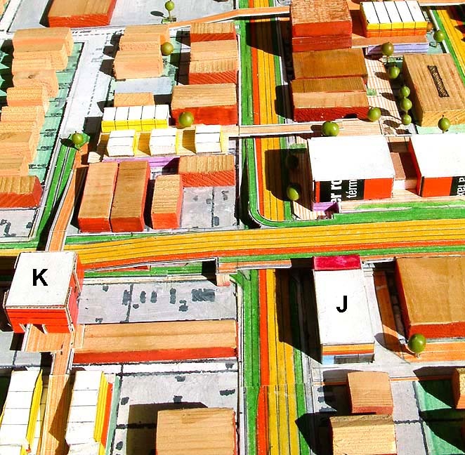
Element J: In the emerging robust development of stage two north of Washington Boulevard , this element would naturally have proximity and likely participation. Washington in an elevated position would allow an extended mall like connection at grade. With additional southerly connection, here again it is assumed that the north – south connection is more important than the east – west pedestrian connection. The assumed land use is a fire station. By interjecting a publicly held use possible additional public pedestrian connections could be part of the building program. An example would be vertical pedestrian connection between grade and a future elevated pedestrian circulation level. By including this capability further needed development may be stimulated to occur.
Element K: An existing strip mall that exhibits a “commercial addition” and incorporates a residential townhouse development to add parking and the benefit of selling the townhouse units to pay for the commercial expansion. The pedestrian ramp and pedway over Washington connects to the “portal”/commercial expansion then over to the pedestrian street between townhouses then southerly to grade. This line connects the neighborhood north of Washington to the neighborhoods south of Washington .
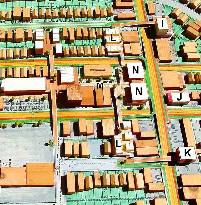
Elements L: These residential projects are like element E but without commercial square footage. Additional parking for use by the area may be advantageously developed however: municipally or privately owned by a condominium subdivision arrangement. Such parking may work well with the emerging mall (element M) or the adjacent theater complex (element N).
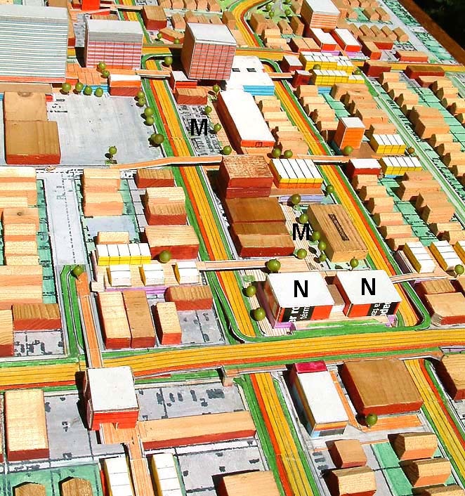
Element M: Element M would be a pedestrian mall at grade that is connecting existing and new development. The high accessibility of the FB intersection central block would attract development over time. Following the study assumption of inspecting small and limited amounts of development, rather than grand sweeping redevelopment of entire blocks, the issue of adding to existing development is explored. It has often been mentioned in elements above that it may be advantageous for adjacent development to build extra parking, and that they could sell (or make available in some way) that parking to an existing commercially developed property owner that may then add square footage without removing development already built. This would be an example of evolving interactions that make the area grow and everyone benefit by the healthy functioning of a mixture of land uses. The evolving mixture of land uses is of course a further example of how “small development” adds up big over time. Convenient shopping to residents within walking distance is an obvious interdependence. Other uses build on that and community wide or regionally wide functions become interjected in a lively village like mix of uses, pedestrian circulation and open space. It is a desirable place to be and live. Segments of FB between highly attractive and accessible intersections would be developed to a lesser degree. “Villages” with multiple higher density mixtures of land uses would naturally develop, and be encouraged to do so, at the elevated grade separated cross streets at half mile (or whatever) spacing along the FB corridor. This phenomenon would naturally happen at simple elevated pedestrian FB crossings as well, but to a lesser degree.

Element N: The land use posed is a theater – entertainment complex. This is an example of a community wide attraction being interjected in to the highly accessible location. The elevated pedestrian plaza and east – west circulation would have connection to the grade level mall (element M). It acts like an “anchor” as in a traditional mall organization. Two levels of vehicular connection are afforded at the stage two elevated Washington Boulevard as well.
Aggregation of parcels for larger development is definitely a major subject in Flow Boulevard corridor development. There will be so much of it. It would be likely to expect in addition to traditional “buy out” methods that there would be room for new innovations that were motivated by existing owners of small parcels to make a large aggregated parcel for development. This is the “block corporation” concept mentioned in the Flow Boulevard 2006 section of this website. This method of project motivation seems to be more organic than a motivation for development imposed from the outside. However both methods are simply ways of assembling parcels and capital for development. Like parcels participating in a single large development would let valuations of parcels being exchanged for project participation shares to be easier than having many different parcels to be part of a long term and evolving development. If there is a will there may be a way, however, and block corporations may be a way to unlock aggregation difficulty.
Element O: Each of the raised Flow Boulevards, Venice and Washington , are O elements as well as the associated up and down ramps to the respective Western and Oxford Avenues. There is more than one way to do the crossing over of Western and Oxford as to whether to include break down lanes (green parking) and sidewalks along with the flow lanes and exclusive bus lane , or not to. This depends on adjacent land use and if there are desired connections to them from the elevated boulevard. There are obvious options in the at grade condition as referenced in the “FB Turning Movements at a Typical FB Intersection Corner” paragraph above.
A more important consideration deals with having the adjacent elements in place that allow the necessary elevated pedestrian circulation to occur.
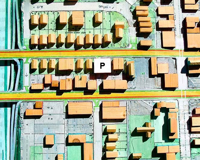
Element P: Here there is a need to provide a turning movement for the Western FB. Between the freeway and Adams there is a need to vehicular circulation to be able to reverse direction on the Western FB. There is an existing street just south of the 10 freeway that would be one way and allow traffic from Oxford to turn left and cross over to Western where another left turn would then allow southerly travel on Western. Between the freeway and Adams there is not such an opportunity to reverse direction from Western to go northerly on Oxford . Hence the need for Element P where vacant parcels would be obtained to provide a one way street to connect Western to Oxford in order to obtain that needed ability to reverse direction. To help offset the cost of the parcels the city would sell the air rights above the new street for the purpose of constructing in this case some commercial office space.
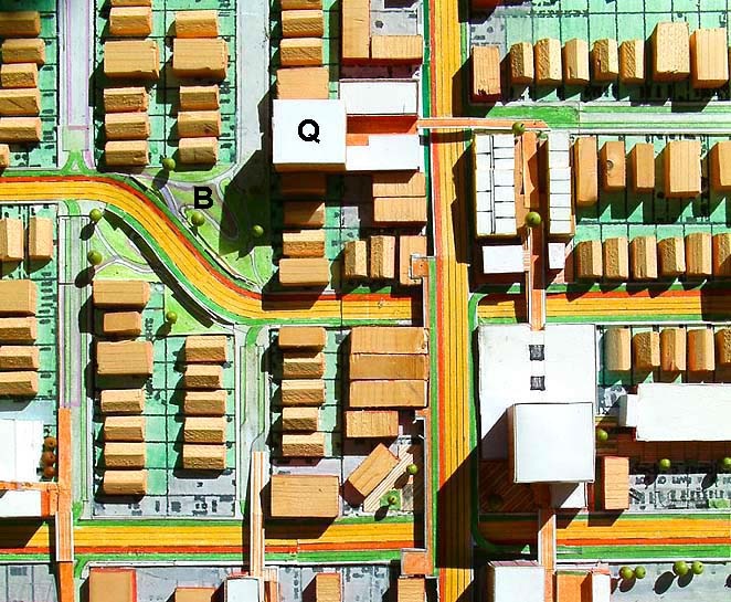
Element Q: This element helps bring forth the security and aesthetics issues of pedestrian circulation and open space. Element Q is not unlike previously discussed residential and raised pedestrian circulation over a platform parking. The raised pedestrian circulation will connect the neighborhood to the south of Venice over through the residential and commercial land use to the park beyond at element B. The normal railing concerns, ramp slope angles and design standards would apply. The issue of security means that the spaces need to be designed with regard to influencing a positive interaction between people. This is the Jane Jacobs “street with a thousand eyes” issue. Integrating pedestrian circulation with residential and commercial land uses will go a long way in creating the watched public space that would have expectations of appropriate behavior in those spaces. It would not hurt to have cameras as well. And a residential tower “over looking” the element B park brings the notion of territory to bear. There should be enough density and people to clearly infuse the park with the right kind of expected behavior, by way of people watching and monitoring what in use will be their territory. And so this principle of being viewed along with use; making places look and be experienced in a good way, would also touch upon the aesthetics of the public spaces. Something for the designers of these elements to further contemplate.
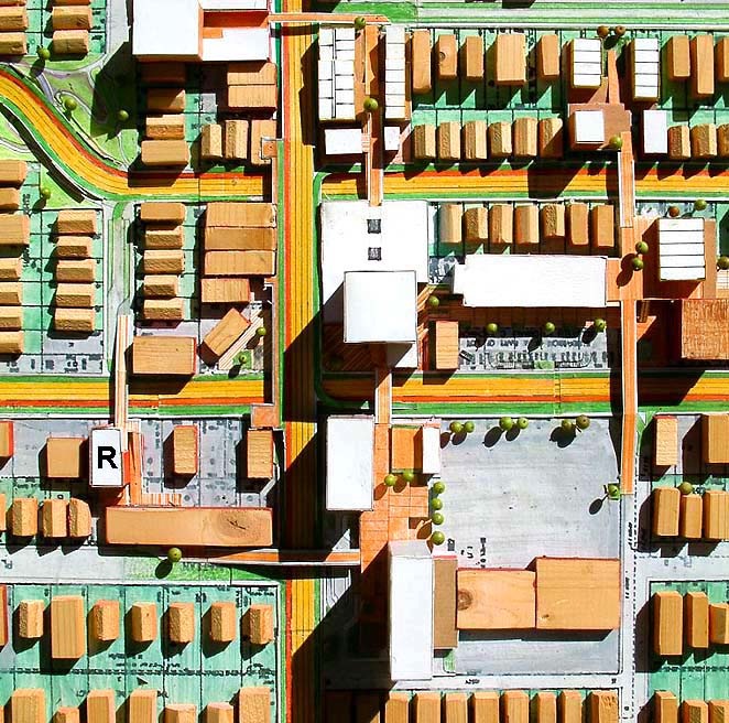
Element R: Element R is another element some what similar to K, but without residential being incorporated. It is essentially an existing small strip mall with an expanded commercial portion. This kind of small additional development with having a rather high ratio of raised pedestrian circulation expense would more than likely need incentives and bonus considerations to bring feasibility. The issue of what is public expense and what is private development expense has not been elaborated upon.
Generally, the FB concept is a low cost method of transportation improvement and community development. Higher and better use of land will create generally more profitable conditions for communities with a higher tax base to draw upon for public revenues and expenditures. Who pays for what and when will have to be discussed here at a later date. Possibly in the next addition to this website development economics can be addressed.
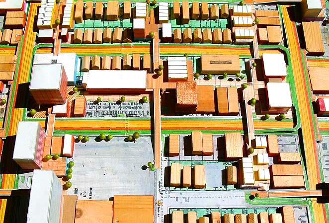
Stage 2 Intersection
A Small Glimpse Forward to FB Stage Three
First of all it can be expected that higher densities than 600 new dwelling units per mile would be developed in corridors. Maybe three or four times the amount (1800 to 2400 DU/mile). Not in all parts of the city but many. And it would be expected that there will be centers with great numbers of additional new units especially because it will be easy to get around Los Angeles with the Flow Boulevard Network connecting centers. The increased capacities afforded by the FB system can support the higher densities as demonstrated by the Travel Demand Analysis section above. The 2030 SCAG projection may very well be met in some form. Probably a bit more spread out, however, than reflected in the LA FB Network section.
In the last 40 years there has been tremendous growth in sprawl form. What was agricultural all around Los Angeles has now become urban and suburban. By curbing most of continued sprawl and making growth occur in forms such as the FB corridor, denser urban settlement would truly be on the upswing in the next 25 years. It would probably surprise most everyone.
Technology will certainly be an influence as well. Transportation in the stage three FB system provides continuous flow of vehicles, no signals. If 40 percent of a LA FB Network were stage three and tied into the free flowing freeway system, high capacities and efficiencies would be remarkable. In 25 years one can expect IT, intelligent transportation (robotic controlled) vehicles mixing in with regular traffic much like hybrids do today. The advantage of IT is that smaller headways between vehicles can take place there by boosting capacities even further. Higher capacities, more integrated travel to go along with denser more sophisticated urbanity is the picture that is forming. Individual mobility is consistent with that setting, but rapid mass transit can deliver convenience as well. Not having to deal with a vehicle can be liberating in many instances in a dense urban setting with vibrant and profuse public transit.
And finally, it is beginning to look like sprawl will be unaffordable as the future unfolds. Social debt and unaffordable obligations are piling up in all quarters of government as well as with individuals. Environmental impacts are creating their own kind of back lash with very real limitations on society. And the world is tending towards leveling the playing field. It would be smart to invest in an economical and enriching city form for everyone’s benefit and see how it performs with the very demanding future.