FLOW BOULEVARD
Santa Monica FB Corridor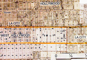
Abstract
Formally the alignment for the Beverly Hills Freeway, but it is still a corridor of immense travel demand through the northerly portion of the LA Basin. As one travels west, boulevards and streets are cut off by the Santa Monica Mountains making passage even more difficult. This corridor will fester with increased congestion as more commercial Westside development associated with an eventual subway and until there is a way to provide adequate through vehicular traffic and protection of residential communities from cut through traffic. This study shows a basic stage one Flow Boulevard alignment with some stage two anticipation of special treatments to provide adequate flow and capacity. This corridor must be secured soon so it can be worked on with urban design solutions over time to make necessary adaptive relationships between transportation and land uses. It is not an easy corridor but a very necessary one to make the Basin work correctly. (Plans and comments made in 2008 follow)
Santa Monica Flow Boulevard Corridor
The Northern side of the LA Basin Flow Boulevard Loop
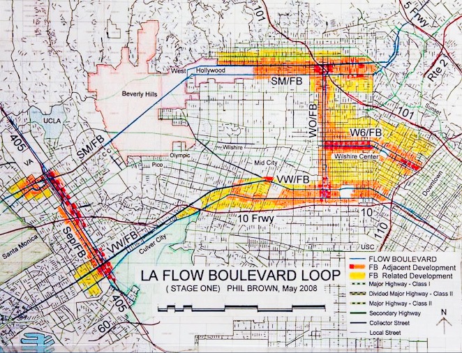
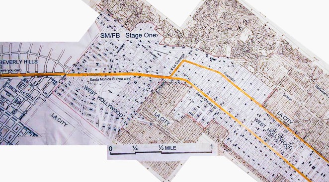
This corridor is the State Route 2 corridor and once upon a time was basically the alignment for the proposed Beverly Hills Freeway. There is strong natural travel demand in this corridor. It is a distinct opportunity to develop this corridor with a Flow Boulevard to meet transportation demands but to also help stimulate and organize community redevelopment in the eastern portion of the corridor and to serve Downtown and the sub-centers along the corridor. The plan images below start in the eastern portion and move west to the 405. Stage One and Two plans are pointed out. This means that Stage One traffic operations would be controlled with traffic signals for a period of probably twenty years or longer. The travel demand analysis for both the No rail plan and its sister plan, the LA Basin FB Loop with Rail, both designate the Santa Monica FB as only needing a Stage One level of vehicular capacity. This would mean that there would basically be few if any grade separations and those separations that would be needed would be many years away. There are only a few exceptions to this general rule and these potential early separations will be pointed out as the corridor is explained below.
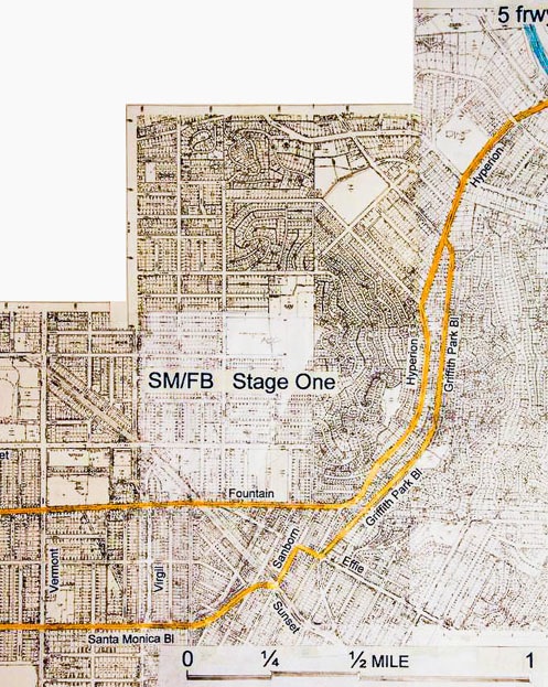
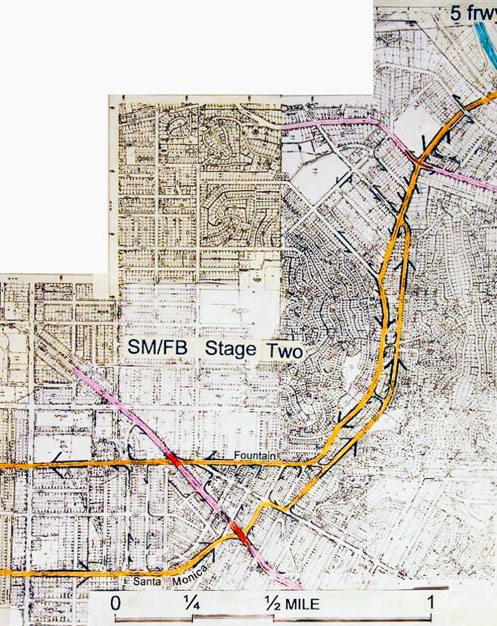
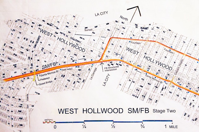
The upper, Stage One image, shows the basic corridor coming off the 5 Freeway area in the upper right hand corner then down using Hyperion and Griffith Park Avenue, then across Sunset into the Fountain Avenue and Santa Monica Boulevard FB pair and over to Vermont Avenue at the extreme left. The image below it shows the flow direction of traffic on the one way pair and the locations of likely grade separations (red elements) that would occur in a Second Stage development of the corridor. The lower “lavender” street is Sunset Boulevard and the upper “lavender” street on the image is Rowena. Where Sunset would need grade separation in maybe 15 to 20 years, Rowena would not need separation for probably three decades because there is much less cross traffic demand so a traffic signal would suffice.
Throughout this area the First Stage would simply have synchronized traffic lights as is typical with the First Stage of a Flow Boulevard (click menu on How the FB Works for explanation of FB operations). The pair of streets, Hyperion and Griffith Park Avenue are generous in width. The adjacent residential area is hillside so there is little cross traffic generated. The blocks between Hyperion and Griffith lend themselves to a village like commercial and R-3 development. This is a nice place to live especially for couples starting out, empty nesters and seniors.
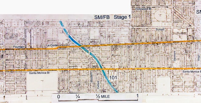
The plan above shows the FB aligning into the Fountain Avenue and Santa Monica Boulevard FB pair with Vermont to the east on the right of the image then moving left and westerly over to Vine Street. This area is urban in character with a grid of streets on near level ground beginning almost at Sunset and going westerly towards Vine Street. Candidates for future grade separated crossings would be Vermont, and possibly a “local pair” of Cahuenga and Vine. Western and Oxford is the easterly side of the LA Basin FB Loop and would eventually have a FB to FB intersection similar to the on shown in model form in the Elements portion on this website (click on Elements and Travel Demand then scroll through both parts of Elements A and B). Grade separation of two FB’s is eventually essential to allow large volumes of vehicles to operate freely. If for example the Western-Oxford FB were delayed in construction at this intersection or if the volumes were small, traffic signals could serve the intersection for many years.
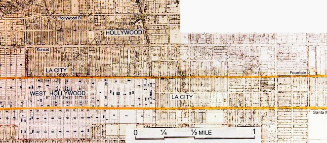
This plan image begins to the right at about Gower Street and extends easterly to approximately Fairfax Avenue. The areas are the Hollywood portion of LA City and then West Hollywood starting approximately at La Brea Avenue. Potential grade separations for north-south streets are Highland Avenue, La Brea Avenue and Fairfax Avenue. Grade separations at these locations are in the 20 to 30 year away category. At that time they would be responding to robust development in the Hollywood area and to through traffic generated and attracted by other development in the corridor.
With grade separation comes a bonus It should be noted that when a grade separation occurs it will take place with great urban design consideration. The planning associated with a grade separation would be to make it an opportunity for adjacent land uses. A full compliment of zoning bonuses, tax advantages and economic considerations to make it viable would accompany the event. A Flow Boulevard incorporates increased density as it responds to increased travel demand. Subsequent studies on this issue will take place on this website.
Fairfax Avenue on the above image is the street just to the left of the LA City and West Hollywood word grouping on the right of the plan image. The Santa Monica Boulevard and Fountain Avenue FB pair continue westerly to La Cienega where the Fountain Avenue vehicular flow would turn down La Cienega and join Santa Monica Boulevard in a combined two way street alignment. To make the FB operate adequately regarding capacity and flow there are no left turns and there will need to be early grade separations at La Cienega, San Vicente and Doheny Drive at the border of Beverly Hills at some point in time. This approach will take special study and will be addressed in more detail subsequently on this website.
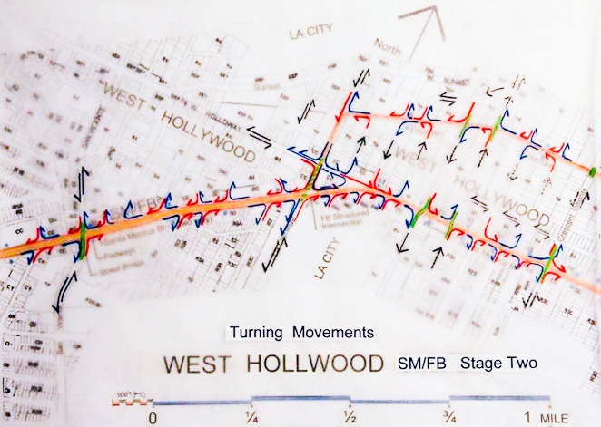
The upper image shows preliminary locations of street grade separations in green. The lower image shows directions of traffic flow in the area. There is much to study but I think the fact that the volumes north-south are relatively low and that internal circulation within this small portion of West Hollywood can be unlocked so to speak, to be given north-south circulation. If people can remember when the Pacific Electric tracks were in a median strip as late as the 1980’s, there was very limited north-south circulation across Santa Monica Boulevard and West Hollywood worked through that period of time. At present the condition is similar. There are still just two flowing lanes in both direction with lots of landscape, merging, left turn and parking lanes. For the Stage One SMFB three flowing lanes would be necessary and the necessary mitigation that would accompany that need (parking structures for example). Signal synchronizing can take place with two way traffic operation if they are a half mile or greater apart. An obvious study may be to introduce pedestrian open space and crossovers at an elevated level on a 660 foot separation to serve pedestrian street crossing while still keeping half mile separations of traffic signals at grade to maintain signal synchronization. The elevated pedestrian circulation and open space may be the beginning of a very unique urban place; one that brings positive urban design identity.
The other urban conceptual option for the area would be to put the through traffic in a tunnel and leave the surface intersections as they are. This “tunnel” option is expressed as a solution in the Beverly Hills area as shown below.
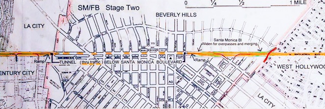
Where a Stage One layout could work for many years, the plan above portrays
a Stage Two FB in the Beverly Hills area to show the longevity of the corridor with the ability to provide even higher capacity within it. At the far right would be Doheny Drive and at the far left would be Century City. From Doheny to about the City Hall area is a road area comprised of Santa Monica Boulevard, a strip of the old Pacific Electric ROW and Civic Center Drive. It has ample width to have both directions of the Santa Monica FB, all kinds of merging lanes and also crossover ramps making connections with Beverly Boulevard allowing all necessary turning movements.
Tunnel option At approximately the City Hall location and Rexford a ramp going down to a tunnel would be built to allow through traffic from between this location and Century City (both directions). So through traffic can quickly by pass Beverly Hills and for traffic that is destined to Beverly Hills the existing Santa Monica configuration at grade with all the traffic lights and left turn pockets allowing turns in and out of Beverly Hills would remain. The tunnel ramps should get back up to grade by the point where the Avenue of the Stars occurs. At this point and with it would also be vehicular crossover ramps connecting the FB to the Avenue of the Stars and Century Park West allowing all turning movements.
The existing segment of Santa Monica Boulevard between Century City and the 405 is basically alright to be used as a FB as it is. There would have to be refinement to lane use, but there may not need to be grade separations early in the FB corridor use. Since signal separations can be maintained at distances greater than a half mile, synchronized signals can still work in the single street configuration layout. Grade separations are really dependent on what happens at the 405. There is already traffic congestion there now. Why improve the flow so much between Century City and 405 just to have bigger jam up at the 405? However, assuming the SM/FB is improved at the 405 the streets west of Century City to be grade separated would be Beverly Glen Boulevard, Westwood Boulevard and there could be another depending on travel demand. The intersection of the two Flow Boulevards is diagramed below at the 405. The intersection can probably have staged increases of capacities over time which in turn affects the staging of grade separations on the SM/FB between Century City and the 405.
Remember that the “west side” of the LA Basin FB Loop is the Sepulveda FB. Previous preliminary plans and area photos occur on this website. Click the menu segment Flow Boulevard 2006, then click on the page 3 box, then scroll down half way on the page until the Sepulveda information appears.
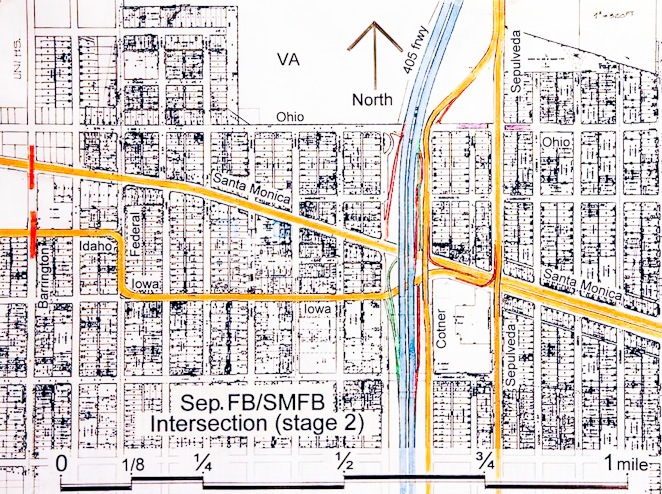
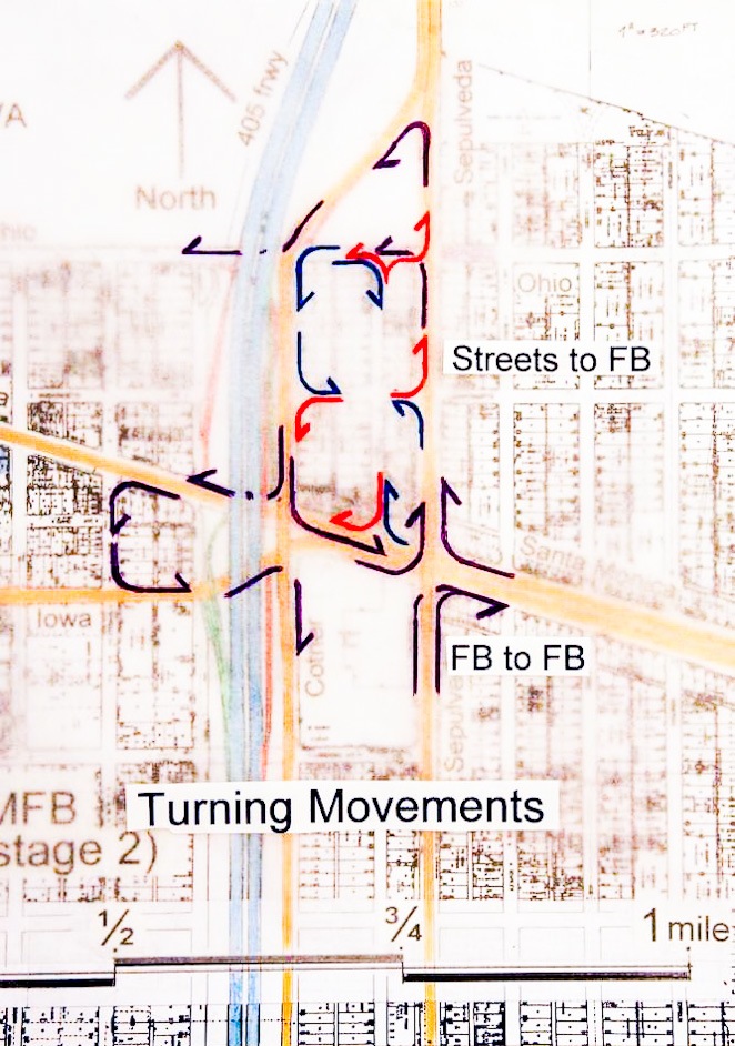
The upper image (above) shows a Stage Two Intersection of the Santa Monica Corridor Flow Boulevard and the Sepulveda Corridor Flow Boulevard. The Santa Monica FB (SMFB) is in the single street alignment up to Sepulveda but will need to be separated into a pair of streets from there on in order to make necessary turning movements and connections with the 405. The extent of the SMFB west of the 405 would depend on travel demand generated by the density allowed to be developed and its connection to the City of Santa Monica.
Sepulveda is paired with Cotner Avenue forming a FB and are both elevated in this second stage. Elevated elements are necessary in this second stage of development, the question is how long can at grade streets with traffic signals in the FB intersection operate adequately before grade separations are necessary. The lower image shows the turning movements that are made FB to FB and FB to local streets. All on and off ramp connections are accommodated between the 405 and the SMFB (both directions). If the FB to 405 connections make this intersection hard to make happen, on and off ramps between the 405 and the Sepulveda FB can be made above and below the SMFB corridor (off image). This would mean one would turn on to the Sep/FB from the SM/FB before getting on to the 405.
Thinking long term, there would be several such sets of connections made between the 405 and the Sepulveda FB in that one of the main reasons for the Sepulveda FB is to provide additional high capacity lanes to serve the Sepulveda “Center” land uses. This would let the 405 primarily be used for through traffic from the Santa Monica Mountains to miles south of the 10 Freeway interchange. The Sepulveda FB adds 3 or 4 lanes in the north and south directions which gets “Center” destined traffic connected quickly and alleviates congestion on the 405. Since the Cotner ROW, or south bound side of the Sepulveda FB ends just north of Olympic, a tunnel under the 405 to connect the south bound traffic with the Sawtelle Boulevard ROW is made for continuity southward. Plan views and photos of this area can be seen on this website by clicking on the menu “FB 2006” segment then the page 3 of that segment and then scrolling to the second half.
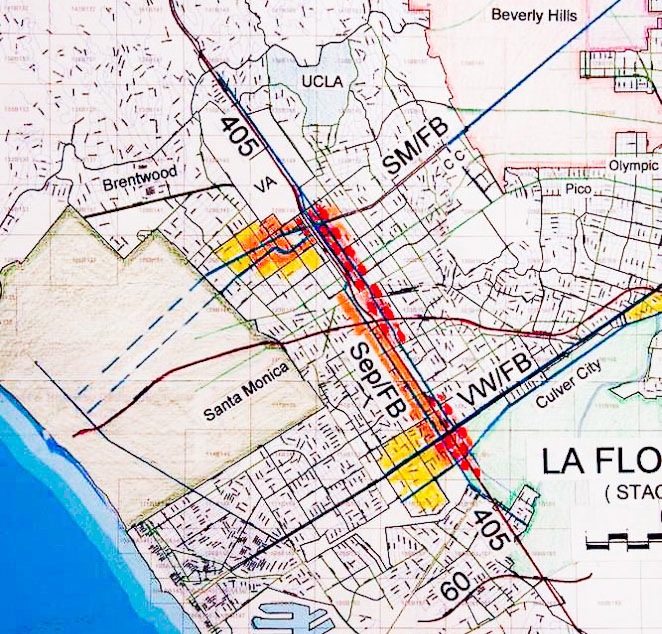
Sepulveda Center and Flow Boulevard
The plan above makes several statements. The Sepulveda FB would be the western side of the LA Basin Flow Boulevard Loop that gives needed circulation around the Basin. It extends the “working life” of the 405 by providing additional capacity in that corridor. The “Center” is an expression of where additional growth can occur without having its attracted additional traffic disperse throughout the Westside communities making greater impacts and congestion. But there is more than that.
At some point it would seem logical to have a major transit connection from the Valley to the LAX area. A FB with BRT can be a first step in providing that build up to a major transit connection. The BRT exclusive lane(s) may have to be on structure at certain locations and outfitted with a longer more train like hardware going over the mountains. There has been advocacy to put a light rail line in a tunnel through the mountains. The choice of a tunnel would I presume have everything to do with rail cars with steel wheels on steel rails not being able to negotiate the grades up, over and down the mountain. It also has everything to do with great expense and therefore probable would not be seen for decades. Rubber wheels on roads would seem to be the logical first phase of increased transit capacity. Thought as to the “guide way” potential of this first phase, so as to be open to be evolved to carry even higher capacity transit vehicles or trains of some kind at a later date, would be a part of the initial design in a FB assisted connection between the Valley and LAX.
A Change in the Scale of How Things Work
Development of a Sepulveda Center along the 405 freeway with a FB and increased transit makes sense from a transportation and land use stand point. Presently a lot of Westside growth is “piling on” in areas like the City of Santa Monica and in communities like Brentwood. And many would like to revive the Wilshire corridor between Western Avenue and Beverly Hills with a subway as a place to pile on there. These areas do not have the infrastructure, or the possibility to realistically attain more, to accommodate continued significant growth. It is a case where a scale change is or has occurred. Land use is out growing its transportation infrastructure. This is referring to a planning change of scale that very well may be irresoluble or unrealistic to try to do so.
Consider the regional scale where regional jobs are attracted to a place of employment from literally all directions and capable of involving all modes of travel. Such a center for regional employment needs good freeway access, local and hopefully regional transit connections and it should be located in a somewhat central location. Along with growth in regional employment it should have room for local growth in housing so that long distance work trips are not the most likely way to get there. Santa Monica does not add up well in any of these desirable requirements. More than half of the area around Santa Monica has barriers to access or growth by way of the Ocean or the mountains. The Sepulveda corridor, on the other hand, has many of the requirements for growth and is well situated to receive the rest. The Wilshire corridor has no freeway access thereby being deficient in vehicular access and there is no easy way to get it without extreme change and major land use impacts.
It should be recognized that The Santa Monica FB corridor subway station would eventually get to the Sepulveda Corridor and an Expo Line station further south. The Sepulveda corridor is perfectly compatible with the idea of greater transit capacity and to have even greater vehicular capacity as well. That scenario makes more sense than putting a subway down Wilshire and into Santa Monica, attracting too much development and traffic that would be forced through residential communities never designed for such an occurrence. A subway to Santa Monica would also leave the 405 in an impossible condition without FB and transit improvement. So it is not Subway to the “Sea” that is recommended, it is Subway to the “Freeway” in the Santa Monica Boulevard corridor that is recommended. Simply stated the Sepulveda Center plan idea puts needed transportation capacity and land use where it is needed and protects existing residential communities from impacts all in a low cost and low disruption manner.