FLOW BOULEVARD
Westside Subway Extension Corridor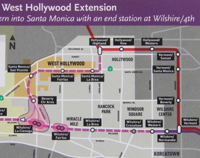
Abstract
This is the initial set of comments on the subway extension made in May of 2009 that emphasized that the wrong corridor was being chosen. The major points that came from this study were that 1/ the corridor should be conceived as a multi-modal transportation corridor, 2/ that the right transportation relationship of the multi-modal corridor should be made to the LA Basin overall street plan and 3/ that the corridor should work well with the existing adjacent communities to protect them from impacts along with nurturing the development of future improved urban environments. The final proposed choice of subway extension alignment has functional flaws and is an incomplete design approach that has not achieved these any of these points well enough. (Comments made in 2009 follow)
Metro Westside Subway Extension Comments
Sent to Project Director David Mieger AICP
At westsideextension@metro.net on May 7, 2009
Mr. David Mieger:
As you may know I have been trying to make a contribution to the subway extension study that is both comprehensive regarding transportation and includes good land use planning. What I have noticed is that at this point of development in the LA Basin, one strong transportation corridor in effect almost defines a land use and transportation Master Plan for the rest of the Basin. I think I may have come across a solution that supports your objectives through Metro and my efforts as well.
Three goals were set out. First to provide a good corridor for the subway extension and of course this has primarily been the work of yourself and Metro by choosing good basic alternatives. Secondly the goal is to have the subway extension fit well into the existing and future pattern of land uses of the LA Basin so as to comprise good planning. The third goal is to solve for elimination of vehicular congestion in the LA Basin. It makes sense to me that after spending billions of dollars that these three goals should be met.
I had been thinking that a third “build alternative” would be necessary to achieve the three goals. I happened to have had a conversation with Ray Tellis the Team Leader for FTA who looks over transit projects including the subway extension. He cautioned that a third “build alternative” would be difficult to develop at this point in the process. Understanding this I see that a small alteration to Alt #11 brings the three goals together in a plan.
Being aware now that a strong transportation facility developed in the Wilshire corridor leads to two unintended negative consequences I propose the following alteration to the Alt #11 plan. By omitting the subway portion from Western Avenue to the proposed Wilshire/ La Cienega station, that should be enough to keep the Wilshire corridor from making an unsolvable vehicular bottleneck in Beverly Hills (BH) and from inducing too much transportation and land use change into the unique LA feature of centrally established residential communities surrounded by major and regional employment. The remainder of Alt #11 is as proposed. I would think that the three stations that would be omitted (Crenshaw, La Brea and Fairfax) would be the lowest ridership stations in the system, so maybe not much is lost by doing that regarding justifying subway costs with ridership. It should also be mentioned here that half of the existing 18,000 bus trips that now occur in the Wilshire corridor would follow the new westerly subway alignment down the SMB corridor.
The BH bottleneck has repercussions throughout the central set of residential communities. With a Wilshire subway and commercial development that follows it, and of course traffic following that; a certain amount of vehicular traffic is established. But now there is a lineal commercial core so to speak going from Downtown to Beverly Hills and beyond. A very major transportation corridor is in the making. It has been established that major development should occur right down the middle of the Basin. The bottleneck in vehicular traffic occurs in BH where the Wilshire corridor traffic encounters the Santa Monica Boulevard (SMB) corridor traffic. At some point in time with one-way pairs or equivalent capacities (75,000 vehicles in Wilshire and over 90,000 in SMB) all the land use between SMB and Wilshire is severely impacted. If you recall my 1972 Flow Boulevard plan Burton Way is paired with Wilshire in BH; it becomes a very unworkable condition. Yet that is what is implied with a strong Wilshire transportation corridor. However if the SMB corridor is a very major transportation corridor and the Wilshire corridor is not, a very workable solution in the long term can be made for traffic not destined to BH; a one mile tunnel for thru traffic under SMB from the City Hall to Century City. That is maybe 40-50 years away, but there is a solution. Not so in a strong Wilshire corridor. A weaker mainly residential corridor with some commercial as it is now; should be manageable and be the objective regarding vehicular traffic in BH.
A further unintended consequence with a strong Wilshire transportation corridor continues with BH being a bottleneck. The by-pass to the bottleneck becomes a fully developed one-way pair in the Olympic-Pico corridor. Now there will be traffic and land use disruption occurring from Western Avenue to beyond the 405 in what are perfectly stable and established mainly single family residential communities.
Two questions come forward. Why induce so much land use change and transportation redevelopment in perfectly good residential communities when there are other areas in the city that need change and redevelopment? Namely areas near Downtown that can be built in combination with improved transportation facilities and connected to employment centers as the state law SB 375 now is looking for. And they lend themselves to a full range of needed housing from low, moderate, middle income levels and even up-scale luxury housing within Downtown.
I keep bringing up the subject of vehicular traffic in what is mainly a subway extension study but I see these are real problems that effect how people will be able to circulate within the Basin. There are many more person trips (pt) in vehicles (autos and buses) than in a subway. I recall counting an increase in the east-west direction of some 330,000 pt (cordon line Fairfax) for 2030. Adding the north-south increase of pt there is an increase in the vicinity of 600,000 pt with a total of over 2.2 million through trips and destined exchanging trips within the Basin in the year 2030. I would guess there would be in effect about 35,000 new subway riders about mid-way (Fairfax cordon line count) and then an additional set of riders moving from bus to the subway for a total of maybe 50,000 subway riders. I can’t see the rationale for generating so many impacts to how the Basin works for such a few number of transit riders. If some of their long range trips are 8 or 12 minutes longer that seems to be a reasonable compromise. It is reasonable for the subway line to be adjusted so that there is an adequate accommodation for allowing vehicular circulation in the Basin and to avoid major land use disruptions.
Viewing the Alt #11 with the 4 mile omission and the Expo Line in plan; a nice rail transit loop around the LA Basin is being developed. This corresponds to the travel demand corridors that my Manual Assignment Transportation Analysis technique has implied. These diagrams can be seen on the Flow Boulevard website at www.FlowBlvd.com (or www.FlowBoulevardPlan.com) in the Travel Demand segment (click on menu to pull it up then scroll). So transit corridors are following travel demand which is as it should be. Speaking of Flow Boulevards and Loops there is a 30 mile LA Basin Flow Boulevard Loop Plan on that same website. This plan acknowledges that with a subway in the SMB corridor, which is a strong person trip corridor; there will even be more trips in vehicles than riders in the subway. The subway will need the backup of a Flow Boulevard to solve for the travel demand in that SMB corridor. If the subway had a total of 50,000 riders at Fairfax there would likely be a demand in the vicinity of 80,000 vehicles which would justify a Santa Monica Flow Boulevard (SM/FB). This is a bit stronger in total pt than in the original assignment that I made in my analysis for the SMB corridor (on the website). I have since recognized that some trips formally assigned to the Venice/ Washington corridor would more than likely be attracted by the SM/FB. This still means that a SM/FB would be a stage one FB without any fancy grade separations and the like, so the SM/FB would certainly fit within the definition of TSM which is a part of your study. The stage one FB with one-way vehicular operation is shown on the website. The website opens when logging on to the correct general area of the site; then click on page 2 to go the Santa Monica FB Plan. A full description of the proposed FB corridor from the 5 freeway to the 405 freeway is made.
This brings up the issue of the Metro TSM proposal of adding buses on most of the major boulevards in the Basin. I am aware of the City Planning Departments’ inclination of adding mixed use (housing over shops, etc) on major boulevard in their Community Plans. I can see that this can eventually led to circulation problems in time as more signals are provided for pedestrians to cross streets with regular two-way traffic. As signals cluster much below half mile separations they cannot be synchronized as you know and they typically become 8 mph crawls with capacities around 400 to 500 vehicles per lane per hour (like Melrose is now). This can lead to gridlock over a large area. Again there is need to have some Flow Boulevards related to the general grid so longer distance travelers can get through to and from work center destinations. The Flow Boulevard is conceived to incorporate both high vehicular capacity and high density land use in corridors. A FB is also conceived as a staged improvement corridor which responds with an increase in vehicular capacity as housing and density increases in the corridor. This is also explained fully in the before mentioned website; click on the menu selections of “How the FB Works” and ”Elements” sections.
I think the introduction of a FB one way pair in the Santa Monica Boulevard corridor can be thought of as in what might be called an expanded TSM program. And it would be a very much needed facility to solve for expected travel demand in that corridor. The existing boulevard vehicular counts are already excessive; Sunset Boulevard with about 55,000 vehicles/day, SMB with over 45,000, Beverly Boulevard over 40,000. I have not refined my projection and assignment for that corridor lately but it is in the range of an increase from 2005 to 2030 of approximately 100,000 pt. The SMB corridor (state route 2) has a naturally strong travel demand, but now it will be attracting an even greater amount of increases by being a subway and development corridor. A thought has occurred to me that a high capacity land use corridor that is partially generated by the FB facility itself should help in justifying higher ridership in that corridor and therefore help justify the subway. Maybe a conversation is worthwhile to see how aspects add up in that regard. There is of course the cost savings of not building the 30 miles of the FB Loop, but only building that amount of FB that occurs in the SMB corridor and solves for travel demand in that corridor. And further, there are all kinds of travel demand projections. My projection is for a little over 0.8% of population increase per year which I understand to be standard. With anti sprawl legislation, expected new urban consolidation with higher populations and truly higher gasoline costs in the future you would think there would be higher travel demands being expected. Certainly within new types of high density corridors that will become more dense with both commercial and high density residential land use, as found in FB corridors connecting to employment centers. It should also be recognized that given all the necessities of life being accessible within the corridor and that the future implies a large supply of seniors who would choose to be transit dependent, these kinds of evolving future new populations should be factored into the major transportation corridors.
The next portion of comments are intended to express the fact that as the Metro subway extension study stands, it can benefit by and be enhanced by incorporating some aspects of the Flow Boulevard concept in a somewhat “expanded” TSM program. The only real expansion at this time in regard to the Metro study would be the incorporation of a first stage FB in the SMB corridor to pick up travel demand deficiencies. It would be beneficial for all concerned however that to recognize the FB concept as being instrumental in helping pick up future deficiencies in overall travel demand and adding desirable problem solving features regarding transportation and land use effecting the entire LA Basin. Of course all major and minor transportation elements need interrelation so the entire system works in concert. It is encouraging to recognize however that there seems to be a coalescing of rail transit and vehicular improved corridors (via the FB concept) by the fact that both systems are developing a “loop” configuration concept around the LA Basin. To be sure the rail system with its Metro authority is providing the “leading edge” for the advancement of transportation networks. My point is that rail transit is not an answer all and comprehensive planning must be recognized for a good outcome to take place regarding the placement of the major transportation corridors.
There are four general comment categories to be added here. They consist of travel demand deficiencies, system costs, operational and planning “fits” and considerations as to how open the system is to future adaptation and evolution in planning options. Generally there can be said that there are major travel demand deficiencies in transportation facilities in the LA Basin. My work indicates that a subway, an Expo Line and some TSM bus expansion as presently proposed by Metro would pick-up somewhere around 25 to 28 percent of the projected increase in travel demand east-west in the LA Basin (ref; see website menu Travel Demand section with projection and assignments for year 2030). The question becomes what picks up that other nearly 75% of unmet travel demand in regards to transportation facilities.
This is a critical issue in regards to people living in the LA Basin in that the traffic congestion would become unlivable if not accommodated with increased capacity. It is also critical for the commuters trying to commute to work and the employers trying to have workers and business interactions by being commuted to. I’m sure Metro would need to plan more transportation improvements to accommodate the deficiency. The suggestion being made here is, the FB concept can add a great deal of capacity within existing ROW for both autos and BRT buses. The initial assignment on the FB website showed how to accommodate all the east-west travel demand increase for 2030 without any subway or Expo Line being added. The difference being with a subway and Expo being added is that grade separations, that occur in stage two of FB evolution may be omitted to a large extent. Grade separations can be a controversial issue and require time by many factions to be worked out. Going forward however there are not low cost ROW’s (Expo line) and lots of available money for subways to add further rail capacity. The cost benefit would be in question as well in that the logical corridors for rail would have been taken (after establishing the SMB subway extension of course). Then again, the spatial layout and development of Los Angeles has brought about an integral “marriage” to autos. The logical pursuit here is to cure the ills of the auto.
Regarding the issue of costs one can say that some low cost “shovel ready” improvement for beginning to establish FB corridors would now be timely. The corridor east of West Hollywood extending into East Hollywood would benefit in other than just transportation improvement as well. A SM/FB corridor as shown in preliminary concept (on the FB website, as the site opens up click on page 2), would give a positive vision and a workable transportation “backbone” to all those communities to bring about that needed community development. It connects and in effect would give stimulus to the previous subway rail development area to the east with the proposed westerly subway extension area by giving vehicular and corridor “route continuity” and image ability. One can envision the density that has been so successful in the West Hollywood area extending east but with more well thought out planning regarding desirable future neighborhood organization and solutions to transportation planning. This corridor is a potential high density corridor with many transit dependent riders by choice and by circumstance.
As mentioned above the 4 miles of subway not built in the Alt #11 alignment; those cost savings can in effect build the 30 mile LA Basin FB Loop which would include three quarters of a billion dollars for more buses. The example here is to explore person trip cost increases between a FB and a subway. But remember regarding the subway extension study the only FB to be built along with the Alt#11 subway alignment is just the segment that corresponds to the corridor study area so reduce by the number of miles that would be actually built with the Alt #11 alignment. The point being is the FB is a low cost addition to add vehicular capacity with but will also add transit ridership to the corridor with the density of land use it develops.
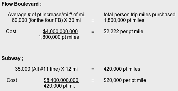
The subway is essentially ten times more expensive in providing capacity increase. On the website on the page the site opens up to is a LA City Revenues and Expense presentation (scroll down to the green doc’s). An analysis is then presented that the FB system essentially pays its own way. Another way to present the cost picture is that stage two and three, a doubling of capacity from the initial stage one capacity (from 1200 to 2400 veh/hr/lane or a 800 veh/ hr/lane increase from the original 400 veh/hr/lane increase) is received for free. Now the cost for per pt mile increase has been lowered by two thirds to $740 per pt mile. That is one thirtieth the cost of subway capacity increase cost. This may be an unconventional cost comparison but given the need to provide capacity increase in the transportation system it is a kind of practical representation for comparative purposes. Again recognize through time the corridor is developing greater transit ridership as the corridor develops more land use.
The area regarding “operation and planning fits” is an area covered fairly well in the comments that I left at the various scoping meetings (Fairfax, West Hollywood, Beverly Hills, Wilshire District and Westwood areas). A general overall planning set of comments, not covered in the scoping meeting comments, are the ideas that are contained in the LA Basin FB Loop Plan (on the website). And the general notions of how the whole LA Basin operates and works together; or lack thereof, is also touched upon here.
The developer orientation of current Westside planning exhibits a crowding towards the west clear out to the City of Santa Monica. This is not particularly good in many respects, but in regards to transportation it is almost humorous. Downtown with all its rail lines, freeways and major boulevards is losing new commercial development to Santa Monica that has just one freeway, is surrounded 2/3’s by ocean and small residential street access and with just 1/3 having normal street grid access. Residents are very concerned about the quality of living in their city ( ala RIFT). It would seem to be both practical and proper that developers should be refocused to areas that need redevelopment for the benefit of the entire LA Basin and the City itself for that matter. The “piling on” in the City of Santa Monica is having Basin wide repercussions.
Transportation planning can help that come about. And in the case of the westerly portion of the Basin the north-south corridor of Sepulveda is a more important line to bring transportation improvement to than an east-west subway line to Santa Monica. There are comments in respects to supporting a “Sepulveda” regional commercial employment center on the FB website and representation to that effect on the LA Basin FB Loop Plan. There are plans as well to that effect on the website menu selection “2006 FB” segment as well. To the extent that a stronger north-south corridor is needed a FB has been proposed for this corridor as well. There are preliminary plans for how a SM/FB intersects the Sepulveda/FB and how connections are made to the 405. These plans are shown on the Santa Monica FB Corridor segment (page 2) of the new group of studies that the website opens up to when you log on to the website. These relationships would affect the Westside subway extension study to the extent that if FB’s are made to accompany the subway they would be taken into consideration as to placement of possible stations and subway alignments. The SM/FB would not be expected to go much beyond the 405. As you stated in a couple of your presentations that going just beyond the 405 with a subway may be well enough. I agree that limiting transportation improvement further west is a good idea at this time. It seems more important that some kind of transit for the Sepulveda corridor connecting to the Valley and LAX makes for a good closure of the Basin rail loop as well and a much needed transit corridor improvement. Here again there would be more transit ridership developed in the Alt #11 alignment if there is a greater attraction made with many more destinations (to and from) by being connected to a strong north-south transit corridor. Much more than the dwindling ridership as a line into the City of Santa Monica would provide.
The last discussion area is about transportation “system openness”. The subway extension is of course part of a closed system with fixed technology. Again the FB concept can be a good companion in major transportation corridor development for the long term. This is because the FB becomes in effect a “guideway” that can receive many different kinds of technologies. In a stage three FB when there is a complete elevated pedestrian circulation system for crossing streets and no grade level pedestrian street crossing this frees technologies from constraints that might be hindered by pedestrians. The probable loosening and opening up a FB would likely refer to accepting a wider range of vehicular types and propulsions as well. Especially so regarding engine or motor size. In that stop and go driving is an objective of the FB system to eliminate, much smaller engines and motors could be employed for urban vehicles. There would certainly be a wide mix of types given older and newer auto “platforms” yet all can be accommodated in the FB corridors.
There is a good chance that the gasoline century of autos is going to be transitioned out of and an electric auto century will be ushered in. With pollution issues brought into an acceptable range the auto can become an even more popular transportation mode than it is now. The FB concept is anticipating an era of density consolidation. That is what SB 375, the anti-sprawl bill signals. So high density corridors with free flowing autos and buses gain a new importance in how the City functions. Line haul subways will continue their purpose with providing access for suburban commuters. A subway in the SMB corridor where high residential density existed from East Hollywood to West Hollywood that was connected to the strongest and among the strongest employment centers of Downtown, Hollywood, Beverly Hills Century City, an emerging Sepulveda Center and of course UCLA/Westwood, should make for strong subway ridership. However there may be a very big new demand for small, efficient autos on a FB system appropriately designed lending itself to an environment where many short trips are accommodated with an overall reduction of VMT and most assuredly less use of energy. The elevated pedestrian circulation system that is removed from the vehicular environment becomes a very desirable addition to an urban fabric and the experience of the pedestrian. This is what the future of a major transportation corridor should incorporate.
So the combination of a FB and a subway in a major corridor has many reasons to occur. Being able to accommodate the full range of length of trips, the capacity to accept them, and to evolve with the changing requirements that transportation will make are three major reasons for it to occur.
You may not be familiar with the proposals Shai Agasie is promoting now regarding total electric vehicle “Transportation Islands”. The strongest candidate so far is all of Denmark. With its wind mills there is almost a perfect match where the night time wind mill operation would recharge the distributed storage batteries of plug-in electric cars. A video is on TED.com under Agasie’s name. With the legislation now on the books to demand such transformations (AB 32, SB 375, etc.) and companies bringing electric auto products to market, it’s a matter of time so it would seem. It is clear that with anti-sprawl legislation and necessary conservation of resources that expanding transportation networks and further suburban sprawl is a misallocation of resources. High capacity transportation serving high density corridors connecting to employment centers seems like the way to go. A subway and FB combined in a corridor fits the criteria.
So the comments to date are comprised of the written and verbal scoping meeting comments at the five scoping meetings mentioned above including the 1973 Wilshire Flow Boulevard Plan (27 inches by 46 inches) that was submitted at the Wilshire District scoping meeting Wednesday April 22nd, this written comment and the referrals to the Flow Boulevard website referred to in this written comment and those segments of the Flow Boulevard website (www.FlowBlvd.com or www.FlowBoulevardPlan.com) referred to in the various texts.
I will start to wrap by saying that I hope that some of the critical comments that were made in the scoping meeting regarding specific traffic and land use conflicts can now be seen from an overall perspective. That overall perspective accepts the subway extension with conditions that in the opinion of the writer need to take place for good comprehensive planning. From the stand point of a LA Basin resident, congestion should be resolved by its elimination in the Basin. But this is also in effect an objective of state law now, that GHG emissions will be essentially reduced by almost 90% by the year 2050. To me it means an all electric flowing transportation system or some kind of equivalent eventually.
And finally I am recognizing and believing that there is a synergistic advantage to combining a FB in a subway corridor. Maybe if I learn more about how ridership is counted that the mutual benefits can be expressed more clearly. I think that the high density residential development of the corridor east of West Hollywood, the Sepulveda center destination, with further connections north- south and the self generating transit ridership that would occur by a Basin transit loop helps justify the Alt #11 choice for a Westside subway extension. Possibly a greater understanding of how dense and full of transit ridership a combined FB and subway corridor would be is a starting point to further establish the combined concept. There is more time in the study to do this and I will work to help support the idea now that the basics of a good corridor can be established.
Sincerely,
Phil Brown