FLOW BOULEVARD
FB Origination and How It Works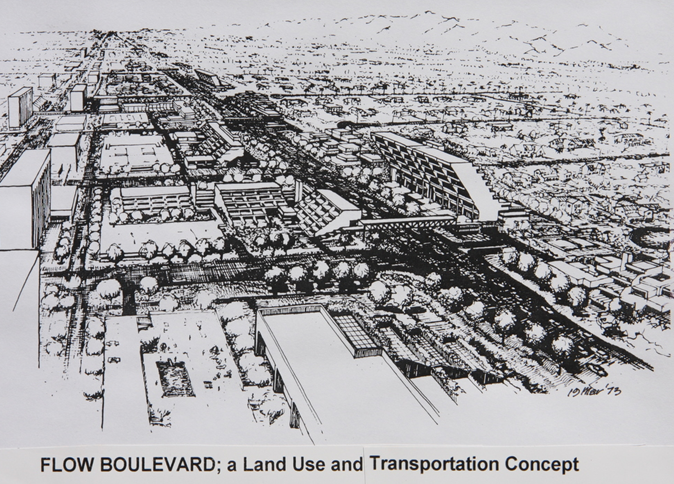
Abstract
The Flow Boulevard (FB) concept originated in 1973 in recognition of the Los Angeles character of having long boulevards in low density settings that needed to move large volumes of traffic and provide for higher density development. This then becomes a staged concept where increased vehicular capacity in the existing street right of way and higher land use development can further advance by grade separating upward a pedestrian circulation and open space environment. This essentially becomes the three dimensional organization of urban elements into environments where vehicles have what they need to operate well and pedestrians have safe and aesthetic circulation areas for their benefit combined with the higher land use corridor. Many nuances and applications have emanated from the original concept and are portrayed on this website. See the text for “how it works” (vehicle operation in detail).
FB Origination and How It Works
2005 Statement
Development of the pedestrian circulation system and the arterial grade separation crossings at mile intervals pose the major development task. Three factors are brought forth: 1/ essentially a high capacity vehicular circulation system is developed by building the safe and aesthetic pedestrian circulation, 2/ the integral compatibility of land use and circulation renewal bring new valid community form into existence to stave off urban deterioration, and 3/ circulation adaptation and land use renewal occurs in a staged process providing significant levels of improvement to each stage with the ease of evolution to the new form.
The result of these new relationships allows a remarkable improvement in traffic capacity to occur with the flow of vehicles developed at grade within existing rights-of-way at obvious low costs. The gain is approximately three-fold; stop and go driving at 600 to 800 vehicles per lane per hour as compared to continuous flow at 1800 to 2200 vehicles per lane per hour with 45 mph maximum speed during the third stage.
First Stage…………..
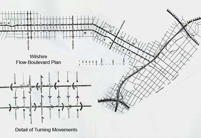
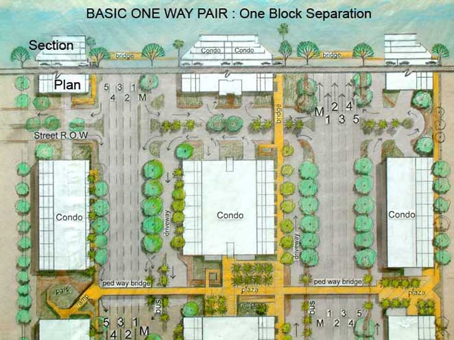
The first stage is to establish a one-way-pair of streets separated by a single block or more, synchronize signalization for the respective flows and omit any unnecessary local street signalization and crossing of the Flow Boulevard. Local streets merge into the Flow Boulevard (FB) or FB traffic merges into the local street, or the local street can be disconnected completely with a cul-de-sac. The probable increase in capacity is approximately 1000 vehicles per lane per hour or a 50% increase.
On a typical corridor, three flowing lanes with parking and merging lanes on each side, or a total of 5 lanes, gives a roadbed of approximately 65 feet. In the Venice-Washington FB I am proposing 4 lanes flowing with merging lanes each side (a total of 6 lanes) for each of the one way pair that makes up the FB.
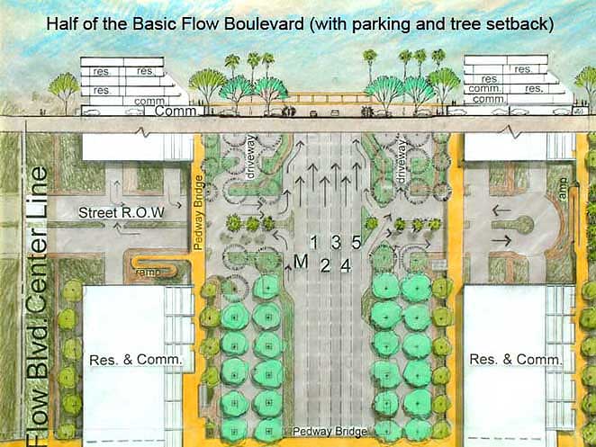
Very little impact would be experienced and the increased accessibility would likely begin to stimulate redevelopment of land use. Such redevelopment would be directed to conform to the new relationships of elevated pedestrian circulation, appropriate ingress and egress to private property, and the like.
Stage Two
Stage two is defined as an intermediate stage where some arterial grade separations and many elevated pedestrian crossings have been developed at critical points along the FB route. A probable capacity at this stage is 1400 vehicles per lane per hour or an increase of 100% over stop and go driving. At this stage only major arterials cross the FB and local streets either cul-de-sac or merge with the FB. Some of the arterials are grade separated allowing the FB uninterrupted flow at that point.
Stage Three
Stage three occurs when the elevated pedestrian system, the elevated arterial crossings and the other FBs that cross the Flow Boulevard are separated along the entire corridor so there is continuous uninterrupted flow. The anticipated capacity is, 2100 vehicles per lane per hour or 200% increase over stop and go driving. By stage three the FB has become a Continuous Flow Boulevard (CFB), a pedestrian free ”guideway”. The implication of utilizing this method of improvement is in regards to transforming the guideway into a non-fossil-fuel and or computer guided facility thereby reducing dependence on oil and increasing capacity even further. This would be a fourth stage at some point that would be open to this flexible design.
The FB concept relates to short and long term solutions and is grounded in the fundamental considerations of, 1/ preserving the high degree of choice and mobility that we are accustomed to in Los Angeles, 2/ the fact that the basic transportation system most all of us use must become pollution free and energy efficient, and 3/ that the derivation of this transportation system be economically affordable, minimally disruptive, serves to structure well functioning communities and desirable urban environment, and continues to be open ended for continual improvement.
The FB approach which begins with the modest goal of making our existing means of fossil-fuel vehicles efficient provides an opportunity to attain the ideal in transportation solutions. The ideal for Los Angeles would be an electric powered system (non fossil-fuel sourced), individually or computer controlled automobiles freely flowing from destination to destination. With an extensive network of guideways (exclusive vehicle only thoroughfares) using both freeways and Flow Boulevards, virtually all of the passenger miles traveled in Los Angeles could be pollution free and conservation minded.
As environmentally desirable as it sounds, it may also be economically and functionally mandatory at some point in time. The key to such a system is to develop a city wide network that may accept such a development of events. The guideway system should be integral with the settlement pattern, aesthetic by road user and observer experience, functionally safe and flexible. The FB can be seen as a practical solution to our transportation problems in the short run and by its flexibility and integral relationships with land use, bring the key that may allow transformation to the ideal transportation system in the long run.